-
Powerful Extratropical Cyclone Triggers Floods and Tornado in Brazil
ALLATRASince December 8, Brazil has been hit by a powerful extratropical cyclone. Due to its slow and unpredictable movement, hazardous weather conditions persisted for several days. In the state of Rio Grande do Sul, a tornado was recorded, with meteorologists estimating its strength at the lower threshold of an F2 category. On the evening of December 8, it passed through the rural area of Travesan-Alfredo-Chavis in the municipality of Flores da Cunha. Thousands of residents were left without electricity. Roofs of approximately sixty houses were partially or completely destroyed, and severe damage was reported to the local church, school, medical center, and several wineries. The following day, the cyclone caused heavy rainfall. The coastal city of Osório experienced one of the most severe floods in its history: water levels rose unusually quickly, inundating areas that had never previously been affected by flooding. In several cities in the state, two to three times the monthly rainfall fell within thirty-six hours. For instance, in the municipality of Amaral Ferrador, 317 millimeters of rain fell during this period. In the state of Santa Catarina, the city of Santa Amaro da Imperatriz, located in the Greater Florianópolis region, received 156 millimeters of rain in a single day. In the São Sebastião area of the municipality of Palhoça, a sudden flash flood swept away a car with a couple and their one-year-old child; unfortunately, all three perished. The downpours paralyzed traffic: major highways in the state experienced multi-mile traffic jams due to flooding. On December 10, the cyclone moved toward the Atlantic coast, bringing squally winds to the southern and southeastern states. In five of these states, gusts exceeded 62 miles per hour. In the state of Paraná, in the Serra do Mar mountains, wind gusts reached 82 miles per hour, an extreme value for the region. In the state capital, São Paulo, the wind toppled around five hundred trees and injured four people. More than six million residents of Greater São Paulo were left without electricity, causing water supply disruptions. Chaos at Congonhas and Guarulhos airports led to the cancellation of hundreds of flights. Meteorologists noted that such an event was rare for São Paulo: the city is accustomed to brief squalls during storms, but not to prolonged strong gusts lasting several hours. As of December 13, a total of six people had died nationwide due to heavy rains, strong winds, and landslides. Neither experts nor local residents expected such a powerful cyclone in December, during the Southern Hemisphere summer. Usually, such systems strengthen over the ocean and weaken over land; however, in this case, the cyclone reached its maximum intensity already over the continent. Pressure at its center dropped to 992 hectopascals, one of the lowest values in recent decades; this record low was observed in Porto Alegre. Before the affected regions could recover, on December 12, a new wave of severe weather struck, bringing strong winds and torrential rains. The climax occurred on December 15, when a cold front encountered intensely heated air, generating squalls with speeds of up to 81 miles per hour. In the city of Bom Princípio, Rio Grande do Sul, the air temperature reached 97 degrees Fahrenheit. The disaster affected more than 54 municipalities, leaving thousands of residents without electricity and water once again. In Porto Alegre, falling branches injured people, while in Cruz Alta, the wind tore off roofs and toppled trees. In the city of Guaíba, a twenty-four-meter-tall statue resembling the Statue of Liberty collapsed. Cyclones and other atmospheric phenomena have increasingly been behaving in completely atypical ways. Scientists associate such abnormal manifestations with a fundamental disruption of energy exchange and circulation in the Earth’s atmosphere. One of the underlying causes of this pathological process is the presence of enormous quantities of microplastic and nanoplastic particles in the atmosphere. How this was discovered, what consequences it has, and whether science has a solution can be explored in the new investigative documentary “Nanoplastics. Threat to Life | ALLATRA Documentary.” https://youtu.be/BVap0MdbCZg #BrazilWeather #ExtremeWeather #SevereStorm #Cyclone #Flooding #ClimateEvents #NaturalDisaster #WeatherUpdate #StormImpact #ClimateReality20 views -
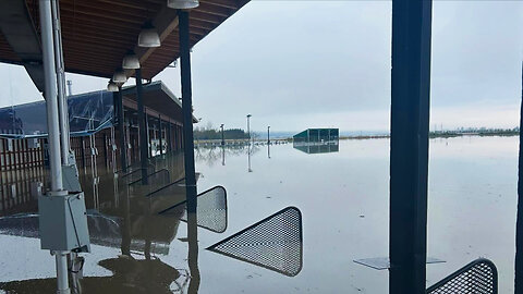
Severe Floods in Washington: Atmospheric River Causes Widespread Damage
ALLATRAFrom December 8 to 12, the U.S. state of Washington was hit by a powerful “atmospheric river." In the Cascade and Olympic Mountains, more than 17 inches of precipitation fell in some areas over 3 days, and several consecutive atmospheric flows intensified the flooding, causing dozens of rivers to overflow simultaneously and triggering one of the heaviest floods in recent decades. At the same time, the warm air characteristic of atmospheric rivers melted the snowpack in the mountains, further increasing the flow of water into already overflowing rivers and streams. As a result, in the western part of the state, especially in the counties of Skagit, Whatcom, King, and Snohomish, water levels reached heights that meteorologists classify as once-in-a-century. A state of emergency was declared across the entire state. Nearly one hundred thousand people living along the rivers were at risk. Residents were urged to evacuate to higher ground, where temporary shelters were opened for them. The hardest hit were areas that are still recovering from the devastating flood of 2021. In the city of Sumas, water levels reached fourteen and a half feet. Rescuers worked from inflatable boats to evacuate people from flooded homes, and several families had to be airlifted from rooftops by helicopters. Dam breaches in King County along the Green River in Tukwila and Pacific caused sudden flooding in the surrounding areas. Landslides and rockfalls blocked mountain passes and roads, including sections of Interstate 90. Strong winds with gusts exceeding 105 miles per hour knocked down trees and power lines, damaging homes and blocking access. The National Guard was involved in the rescue operations: hundreds of servicemembers went door to door in dangerous areas, assisting residents with evacuation. Federal and state agencies, including FEMA, were activated to provide aid to those affected. According to official data, one fatality was confirmed: a man drowned while attempting to drive on a flooded road, ignoring warnings. Floods like this are becoming part of a new climate reality. Scientists are increasingly pointing to nanoplastic as one of the factors capable of affecting climate processes and more. Its particles have already been detected everywhere: in soil, water, the atmosphere, and even the human body. The scale of this threat is explored in the film “Nanoplastic: A Threat to Life”. https://youtu.be/BVap0MdbCZg #WashingtonFloods #AtmosphericRiver #SevereWeather #Flooding #ClimateEvents #NaturalDisasters #EmergencyResponse #ExtremeRain #WeatherUpdate #USWeather38 views -
Morocco Under Water: How Storm Emilia Turned Rain Into Disaster
ALLATRAIn mid-December 2025, the powerful storm Emilia swept across large parts of Northwest Africa and southern Europe, causing severe consequences, most notably in Morocco. The nationwide death toll from the deadly natural disaster reached 41 people. On December 13, intense downpours struck Tetouan and nearby areas in the north of the country. In a short period of time, more than 1.18 inches of rainfall fell, a critical volume for the city’s drainage system. Water rapidly accumulated on streets and in low-lying areas, leading to localized flooding, inundation of narrow streets, and serious disruptions to traffic. The situation was further aggravated by strong winds with gusts of 37 to 47 miles per hour, which worsened conditions along the coast and caused heavy sea swell. The most tragic events unfolded on December 14 in the Atlantic coastal province of Safi, about 205 miles south of Rabat, where exceptionally intense thunderstorm rainfall fell within nearly an hour, triggering a sudden flash flood. According to official data, at least thirty-seven people were killed, and dozens more were injured. In the city of Safi and its surroundings, residential neighborhoods, the old town, shops, and industrial zones were flooded. Powerful torrents of water swept away vehicles, destroyed roads, and isolated entire districts. Morocco’s prime minister reported that 1.6 inches of rain fell over a short period in the historic Bab-Chaaba district, through which a river runs, a factor that led to numerous casualties among traders and workers. Tragic incidents were also reported in other regions of the country. In the southern province of Tinghir, four people died when a vehicle was carried away by a violent current and overturned into a river between Fezou and El-Hafira. Authorities warned of continued rainfall, closed schools in four provinces, and launched large-scale rescue and recovery operations. According to experts, the scale of the devastation in Morocco is linked to a seven-year drought, after which over-dried soils and depleted reservoirs sharply intensified surface runoff during short-lived but extreme rainfall events, turning them into destructive floods. However, the root cause lies in the unimaginable intensity of precipitation, which continues to increase year after year. Scientists have found that the formation of such extreme rainfall is being facilitated by a human-made factor. More details are presented in the new film: “Nanoplastics. Threat to Life | ALLATRA Documentary” - https://youtu.be/BVap0MdbCZg #StormEmilia #MoroccoFloods #ExtremeWeather #FlashFloods #ClimateCrisis #NaturalDisasters #HeavyRain #FloodAlert #WeatherNews #GlobalClimate31 views -
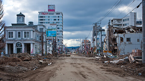
Magnitude 7+ Earthquakes Hit Alaska and Japan — Aftershocks Continue
ALLATRAOn December 6, a spike in seismic activity was recorded beneath the Hubbard Glacier. The main shock, with a magnitude of 7.0, occurred at 11:41 a.m. Alaska time. Its epicenter was located approximately 56 miles to the northeast of the city of Yakutat in the state of Alaska, United States, and about 155 miles to the west of Whitehorse, Yukon Territory, Canada. The hypocenter lay at a depth of only 6.2 miles. Despite the strength of the quake, no tsunami warning was issued; nor were there any reports of serious destruction or casualties. The tremors from this seismic event were felt over a considerable distance: residents of cities in southeastern Alaska — including Juneau and Anchorage — as well as in Canada’s Yukon, felt the shaking. Following the main shock, an intense series of aftershocks began. Over the next four days, at least 230 repeated events with magnitudes of 3.0 and higher were recorded, including five strong ones with magnitudes up to 5.8. Already on the evening of December 8 at 11:15 p.m. local time, another powerful seismic event occurred — an earthquake with a magnitude of 7.6 — about 50 miles off the eastern coast of Japan’s Aomori Prefecture. The focal depth was 31 miles. The strongest shaking was observed in the city of Hachinohe. The earthquake generated a tsunami: in the port of Kuji in Iwate Prefecture, wave heights reached 28 inches, and in the town of Urakawa in Hokkaido — up to 20 inches. The consequences in Aomori Prefecture were significant. 45 schools were damaged, and classes were canceled in 318 educational institutions. In the port of Hachinohe, soil liquefaction occurred — fountains of sand and water erupted from cracked ground in a parking area. In the city hospital, three floors were flooded due to the activation of the fire-extinguishing system. Hundreds of households in the cities of Shichinohe and Mutsu were left without water and electricity. A total of 50 people in the prefectures of Aomori, Iwate, and Hokkaido were injured, mostly due to falls and being struck by objects. The seismic event also hit the region’s transportation system: service on the Tohoku Shinkansen high-speed rail line between Fukushima and Shin-Aomori was suspended, and three trains were stranded on the tracks. Service was halted on several subway lines, including in Sapporo. Hokkaido expressways were temporarily closed, and ferry service across the Tsugaru Strait was also suspended. About two hundred passengers spent the night in the terminal of New Chitose Airport, the largest in Hokkaido, due to safety inspections of the runways. Critical infrastructure was also put at risk: at the Tomato-Atsuma thermal power plant in Hokkaido Prefecture, one of the power units shut down automatically. At the nuclear-waste reprocessing plant in the village of Rokkasho, Aomori Prefecture, about 172 gallons of water containing radioactive substances spilled from the spent fuel storage pool. The leak was promptly contained. Within two days after the main shock with a magnitude of 7.6, at least seven powerful aftershocks occurred, with magnitudes reaching 6.6. It must be acknowledged that seismic activity on our planet is steadily increasing, and earthquakes with high magnitudes have already become more frequent. At the same time, there is a factor that is still hardly considered by anyone in the scientific community. It exacerbates the geodynamic crisis and intensifies natural disasters by hindering the release of heat from the planet’s interior. This concerns micro- and nanoplastics. This process is described in detail in the report “NANOPLASTICS IN THE BIOSPHERE. FROM MOLECULAR IMPACT TO PLANETARY CRISIS.” #Earthquake #SeismicActivity #BreakingNews #NaturalDisaster #TsunamiAlert #Aftershocks #AlaskaEarthquake #JapanEarthquake #ClimateAnomalies #climatecrisis #climatedisasters53 views -
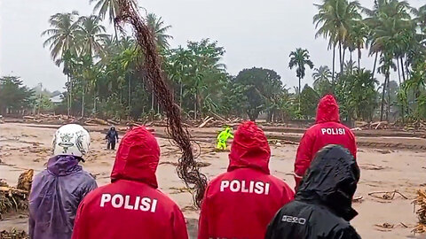
Cyclone Ditva Devastates Sri Lanka: Floods, Landslides, and Nationwide Emergency
ALLATRAOn November 28, Cyclone Ditva struck the eastern coast of Sri Lanka, bringing torrential rains and destructive winds. The disaster affected all twenty-five districts of the country, and floods and landslides caused serious damage to approximately 22 of them. The Central Province, the North Western Province, and the Uva Province were the most severely affected. Rivers and reservoirs overflowed, flooding cities, villages, and agricultural fields. Because of landslides and flooding, passenger train service was halted, and many highways across the country were closed. The scale of destruction is staggering: seven hundred eighty-three houses were completely destroyed, and more than thirty-one thousand were damaged. More than two hundred thirty thousand people were forced to leave their homes and move to temporary shelters. More than one and a half million people were affected across the island. One-third of the population lost electricity and water supply, ten bridges were destroyed, and more than two hundred roads remain impassable. Government institutions and schools were closed. A state of emergency was declared throughout the country. More than twenty-four thousand police officers, army personnel, and servicemembers were deployed to provide assistance and conduct rescue operations. Even the city of Colombo, the commercial capital of Sri Lanka, did not escape severe flooding. The speed at which the water rose in the city surprised local residents, who are accustomed to seasonal floods. According to them, this time the flooding was much faster and more extensive than usual. A resident of the central part of the country reported that about fifteen houses in her area were buried under boulders and mud. According to her, none of the residents of those houses survived. On November 29, in the north-central Kurunegala area, a nursing home was flooded, resulting in the deaths of eleven elderly people. The President of Sri Lanka stated that the country had faced the most serious natural disaster in its history. As of December second, the death toll had reached four hundred sixty-five people. Another three hundred sixty-six people were reported missing. The scale of the consequences of this natural disaster is colossal. But unfortunately, this is only the beginning; so far, there are no signs that the escalation of cataclysms will stop or be reversed. However, if you think that floods happen on this island anyway, and this time it was just a little stronger, and that such a disaster will bypass your region, watch the film “Nanoplastics. Threat to Life | ALLATRA Documentary”, and you will understand that there is no longer any safe corner on our planet. #SriLankaFloods #CycloneDitva #ExtremeWeather #ClimateEvents #NaturalDisaster #FloodingCrisis #WeatherNews #DisasterUpdate #GlobalWeather #EmergencyResponse18 views -
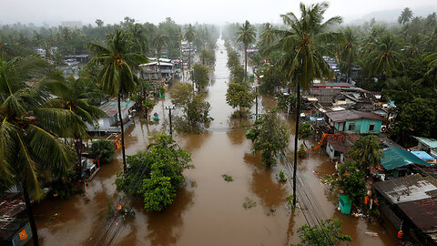
Thailand Declares Emergency After Severe Flooding
ALLATRAThe relentless torrential rains that struck southern Thailand led to a large-scale disaster in ten provinces at once. More than two million seven hundred thousand people were affected, and about forty-five thousand residents were forced to urgently evacuate. Due to the flooding of railway tracks, the state railway temporarily suspended train service in the southern direction, and hundreds of tourists found themselves blocked in hotels and at airports, unable to leave the disaster zone. On November 25th, a state of emergency was declared in the country. The army, helicopters, and even the only aircraft carrier in Thailand were deployed for rescue operations; together with a flotilla of fourteen boats, it was sent to assist the victims. The most severe situation developed in the Hat Yai district of Songkhla Province — the most powerful flood in the past twenty-five years occurred here. The city, which is a major business and tourist center, was hit by record rainfall: at Hat Yai Airport alone, within twenty-four hours — from the morning of November 21st to the morning of November 22nd — 14.7 inches of rain fell. The water level rose to eight point two feet. Many people spent several days on the roofs of their homes without water or food. Huge snakes were floating along the flooded city streets, adding even more terror to the chaos. The main hospital of Hat Yai was also submerged, where at that time there were six hundred patients, including fifty people in intensive care. Helicopters were used to deliver food, fuel for generators, and to carry out the emergency evacuation of critically ill patients. Thirty newborns were also in mortal danger when water flooded the two lower floors of the building. The rampaging elements claimed the lives of thirty-three people. Most of the victims drowned or died from electric shock. The cause of this flood was not a tropical cyclone, as is usually the case in the region, but a stationary low-pressure zone that triggered a rare and extremely dangerous phenomenon — the so-called “rain bomb,” when a colossal volume of precipitation falls within a short period of time, comparable in destructive force to a powerful hurricane. The development of events was predicted only two hours before the impact of the elements. Moreover, the main blow occurred late at night, when residents had practically no time for either preparation or evacuation. Such a catastrophic development of events, not only in tropical countries but throughout the entire world, had been forecast by scientists of the international scientific collective ALLATRA several decades ago. Unfortunately, at that time, the global public ignored this warning. And in the coming years, many scientifically grounded scenarios of what will happen with cataclysms on Earth were voiced. We invite you to read this report, as understanding what is happening can save your life. #ThailandFloods #HatYaiFlood #ThailandWeather #RainBomb #SevereFlooding #ExtremeWeather2025 #ClimateUpdate #DisasterNews #FloodRescue #SouthThailand29 views -
Ethiopia Volcano Awakens After Thousands of Years | What Scientists Are Watching
ALLATRAOn November 23, Ethiopia experienced a sudden and powerful eruption of the Haili-Gubbi volcano. The ash plume rose to an altitude of about nine miles, disrupting the air corridors connecting Africa, the Middle East, and South Asia. A “red code” aviation alert was issued immediately for the region, as also reported by the Toulouse Volcanic Ash Advisory Center. Satellite data obtained on November 24 revealed not only an extensive volcanic-ash plume but also a strong sulfur-dioxide release at altitudes ranging from about three miles to roughly eleven miles. These measurements clearly indicate major volcanic activity: the IASI-C satellites detected an SO₂ plume with a total mass of more than fifty-eight thousand short tons. The gas-and-ash plume persisted in the atmosphere for a long time after the eruption, gradually drifting over the Red Sea and moving toward Oman and Yemen. What makes this event especially remarkable is that Haili-Gubbi had no confirmed eruptions for nearly twelve thousand years; previously, the volcano exhibited only weak gas emissions. Its sudden awakening has become yet another indication of the growing geological activity on our planet. Dr. Egon Cholakian has outlined the fundamental changes in geodynamic catastrophes that await us in the coming years. We highly recommend watching his analysis. #EthiopiaVolcano #VolcanicEruption #BreakingNews #NaturalDisaster #ExtremeNature #GeologyUpdate #EarthActivity #GlobalWeather #DisasterNews #ScienceAlert61 views -
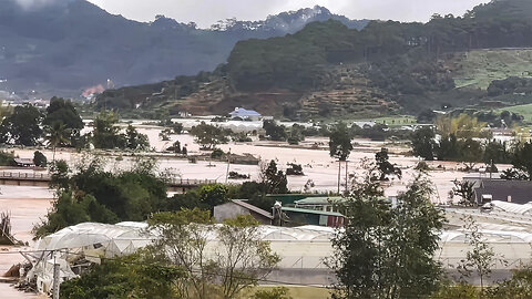
Record Rainfall Triggers Massive Floods Across Vietnam
ALLATRAUnprecedented floods have unfolded in South-Central Vietnam: the amount of rainfall has exceeded all historical norms. In less than 24 hours, major rivers broke decades-old records: the Dinh River surpassed the mark from 1986, the Kilo River exceeded the peak of 2009, and the Ba River broke the record from 1993. Local hydropower plants were forced to release water, which only increased the destructive power of the disaster. The situation was especially severe in Dak Lak Province, where in Son Hinh, from November 15th to November 21st, more than seventy-three inches of rainfall fell — an abnormal amount even for the rainy season. The water came so rapidly that people had to break through the roofs of their homes and climb onto them to escape the rising flood. Social media was filled with desperate pleas for help. Some families spent up to thirty hours on rooftops. In Dak Lak alone, sixty-three people died. Nationwide, the number of victims reached 98, and another ten people went missing, according to the Department of Dyke Management and Disaster Prevention as of November 26th. In Khanh Hoa Province, in Thai-Nha Trang, the water rose to between thirteen and sixteen feet. In Cat Tien District of Lam Dong Province, residents were completely cut off from the outside world, and authorities delivered food and essential supplies by boats and specialized equipment. The floods caused enormous damage to infrastructure and agriculture: nearly one point two million consumers were left without electricity, and two sections of national highways were closed due to landslides. More than four hundred houses were destroyed, over two thousand were damaged, and more than two hundred thousand were flooded. About two hundred twenty-two thousand acres of rice and other crops were destroyed, fish farms were wiped out, and about nine hundred twenty thousand head of livestock and poultry were lost. To handle the aftermath, the Ministry of Defense deployed more than forty-two thousand service members and more than one thousand two hundred units of equipment, including ships, boats, specialized vehicles, drones, generators, and pumps. The media are increasingly using terms such as record-breaking, abnormal, and historic to describe the floods, and experts explain this rapidly increasing abnormality of such events by warming and rising atmospheric humidity. But almost no one is taking into account one factor that is now making the rains truly extreme. Dr. Egon Cholakian explained this factor in detail in his video report. #VietnamFloods #BreakingWeather #ExtremeWeather #NaturalDisaster #FloodCrisis #ClimateUpdate #WeatherNews #DisasterReport #WorldNews #StormAlert55 views -
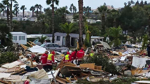
Storm Claudia Leaves a Trail of Chaos Across Portugal, Spain, France, Ireland and the UK
ALLATRAThe storm “Claudia” developed from a broad area of low pressure that had already brought early cold weather and snowfall to eastern Canada and the northeastern United States in early November. As the system moved over the Atlantic, it strengthened, and after slowing down to the northwest of the Iberian Peninsula, it began accumulating enormous masses of warm, humid air. Beginning on November 11, the Spanish region of Galicia was hit. Within a single day, up to 5.9 inches of precipitation fell, and such volumes of water turned city streets into rushing torrents. Rivers, overwhelmed by the sudden inflow, began overflowing their banks, creating a flood threat for nearby settlements. In Portugal, “Claudia” struck with particularly destructive force. The most dramatic events unfolded in the popular tourist city of Albufeira, located in the southern region of the Algarve. It was here that a tornado formed in the morning: the vortex hit a hotel restaurant at the moment when several dozen people were having breakfast inside. The tornado’s destructive power left 28 people injured, including six children between the ages of two months and seven years. Four adults with serious injuries were hospitalized. The tornado also tore through a campsite, where a woman was killed while inside her motorhome when the storm struck. On November 15, another tornado hit the municipality of Silves, where several buildings were destroyed and two residents were left homeless. In Faro District, wind gusts reached approximately 69.6 miles per hour. Torrential downpours combined with hurricane-force winds toppled dozens of trees, damaged power lines, and caused widespread electricity outages. In the village of Azeitão, located in the municipality of Setúbal, a landslide collapsed a section of road. Traffic was completely blocked in both directions, significantly complicating the work of emergency services. In the town of Fernão Ferro, located near Lisbon, water levels rose so rapidly that during the night, it burst into the home of an elderly couple. They were unable to escape and drowned. The scale of the storm’s impact across the country was enormous: according to the National Authority for Emergency and Civil Protection (ANEPC), three thousand three hundred sixty-three incidents directly related to the severe weather were recorded throughout Portugal. As it moved farther north, “Claudia” reached the United Kingdom. In England and Wales, the situation was worsened by sudden flooding. In the town of Monmouth, nearly four point seven inches of rain fell overnight, exceeding the average monthly rainfall. The River Monnow breached its defensive structures, and on the morning of November 16, residents found most of the town submerged. In southern England, several railway lines were closed — both due to fallen trees on the tracks and the high water levels. Ireland fared no better. The counties of Wexford and Laois were hit hardest. A sharp rise in river levels led to the flooding of homes and businesses, and about five thousand people were left without electricity, according to ESB Networks. In France, however, the same storm produced a completely different yet no less unusual phenomenon. Due to an influx of warm subtropical air into the southwestern regions of the country, temperatures rose sharply. In one locality, a new November record was set — 85.6 degrees Fahrenheit, an entirely atypical value for this time of year. With each new natural disaster, we witness how its scale continues to grow, and more and more territories simultaneously fall under the destructive force of nature. Unfortunately, this is consistent with — and fully confirms — the mathematical model of the exponential growth of natural catastrophes on our planet that the scientific community of ALLATRA presented to the public several years ago. We invite you to familiarise yourself with these forecasts; they may save your life. #StormClaudia #IberiaStorm #PortugalTornado #SpainFloods #UKFlooding #IrelandStormDamage #ExtremeWeather2025 #EuropeanWeatherUpdate #NaturalDisasterNews #ClimateAnomalies36 views