-
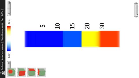
027.[Geo-Physical] Geoseeker
DUMBs in Far East Asia극동아시아의덤들: China,Korea,Japan,Taiwan,and PhilippinesThe thumbnail of this video shows a cavern 30 meters underground. The signal in this thumbnail is an image from a Geoseeker single point scan taken on October 13, 2015. According to the dowsers, there is a North Korean invasion tunnel here in Jigeum-dong, Namyangju-si (South Korea). The maximum depth of 250 m for the geoseeker that measures the resistivity of the multilayered media is usually 50 m shallower than the 'apparent' tunnel line attached to the DUMBs. The dowser estimates the minimum depth of the DUMBs to be 500 m and the maximum depth of the DUMBs to be 4 km based on his own exploration. As already mentioned, the distinction between a DUMBs and an 'apparent' tunnel attached to it is an arbitrary and self-imposed technical distinction of the dowser, and has no absolute meaning. Anyway, a geoseeker with a maximum exploration depth of 250m cannot detect a signal from a DUMBs. As of May 2025, the only ways for a dowser to detect a DUMBs are dowsing first and then the XL16 Imager Pro. Even with the latter, it can only occasionally detect a DUMBs signal when the geomagnetic conditions are good. However, with dowsing, whether it is map dowsing, indirect dowsing, or direct dowsing, it can in principle detect any DUMBs signal in the Earth, anytime, anywhere. 이 동영상의 썸네일은 지하 30m에 동공이 있음을 보여준다. 이 썸네일의 시그널은 2015년 10월 13일에 행해진 지오시커 싱글지점 스캔 이미지이다. 다우저들에 따르면 남양주시 지금동(남한)의 이곳에 북한남침땅굴이 있다. 여러 층을 이루는 매질들의 비저항 값을 측정하는 지오시커의 탐사 가능한 최대 깊이 250m는 덤에 붙는 '겉보기' 땅굴라인 보다 보통 50m 더 얕다. 그 다우저는 자신의 탐사에 근거하여 덤의 최소 심도를 500m로, 그리고 덤의 최대 심도를 4km로 잡고 있기 때문이다. 이미 언급된 것처럼 덤과 그리고 덤에 붙는 겉보기 땅굴의 구분은 그 다우저의 임의적이고 자의적인 테크니컬한 구분일 뿐 그것에 절대적 의미는 없다. 아무튼 탐사 최대 깊이가 250m인 지오시커로는 덤에서 오는 시그널을 잡아 낼 수 없다. 2025년 5월 현재 그 다우저가 덤을 잡아 내는 방법은 먼저는 다우징이요 그 다음에는 XL16 이미저 프로이다. 그나마 후자로는 지구자기적 조건이 맞아 떨어질 때야 가능하기 때문에 가끔 덤의 시그널을 잡아 낼 수 있을 뿐이다. 그러나 다우징으로는 그것이 맵 다우징이든, 간접 다우징이든, 직접 다우징이든 언제든지 어디서든 지구 안에 있는 그 어떠한 덤의 시그널도 원리적으로는 잡아 낼 수 있다.72 views 1 comment -
026.[Geo-Physical] Boxler 4
DUMBs in Far East Asia극동아시아의덤들: China,Korea,Japan,Taiwan,and PhilippinesThe dowser uploaded a video titled 'CIA is on the rise! 50% of the gold in Moonhyeon-dong belongs to the US government! ', which was released on YouTube about 7 years ago but is now deleted, here on Rumble, with the video number '002.' This is because there were 'apparent tunnels' for various purposes entering the square of the Japanese underground torpedo factory where the gold was, which he and two colleagues had explored for 4 days. The term 'apparent tunnel' is the dowser's technical term for a tunnel less than 300 m deep, attached to (or emerging from) a DUMBs several km underground. The thumbnail of this video is a 3D image of the GPR data acquired at that time, processed with Boxler 4. It clearly reveals a single network of two 'apparent' tunnel lines (76m deep and 2m wide)caught on the L-rod during hill dowsing. The location of the gold bullion piles discovered by Mr. Jeong Chung-je is about 50 meters below this hill, and as of May 2025, the location is currently camouflaged inside a factory building. Seven years ago, the dowser continued his exploration of underground torpedo factories in three nearby locations, including this one. The results of the Busan Munhyeon-dong underground torpedo factory investigation further increased the credibility of Mr. Jeong Chung-je’s words. Solving this problem is as difficult as President Trump eradicating the world’s evil deep state. No, it may be impossible. 그 다우저는 ' CIA가 뜬다! 문현동 금의 50%는 미국 정부의 몫! ' 이라는 제목의 7 년 여 전 유튜브에서 공개됐으나 지금은 삭제되어 없는 영상을 이곳에 영상번호 '002.'으로 재 업로드했다. 왜냐하면 그가 동료 2인과 함께 4일 간 탐사했었던, 그 금괴가 있는 일제 어뢰공장 땅굴 광장으로 여러 목적의 '겉보기 땅굴' 라인들이 진입하고 있었기 때문이다. '겉보기 땅굴'이란 낱말은 수 km 지하에 있는 덤들에 붙는(덤들에서 나오는) 300m 미만 심도를 지니는 땅굴을 가리키는 그 다우저의 테크니컬한 용어이다. 이 영상의 썸네일은 그 때 획득한 GPR 데이터를 복슬러4로 프로세싱한 3D 영상물이다. 언덕 다우징에서 엘로드에 걸린 두 개의 심도 76m 폭2m '겉보기' 땅굴라인 2 개로 이루어진 하나의 망이 고스란히 드러난다. 정충제 선생이 발견한 금괴 더미들의 지점은 이 언덕 바로 아래 약 50여 밑에 있고, 2025년 5월 현재 현재 그 지점은 공장 건물 안에 위장되어 있다. 7년 전에 그 다우저는 이곳을 포함한 인근 세 곳에서 지하 어뢰공장들에 대한 탐사를 이어갔었다. 부산 문현동 지하어뢰공장에 대한 탐사 결과는 정충제 선생의 말에 대한 신빙성을 더욱 높여 주었다. 이 문제를 해결하는 것은 트럼프 대통령이 세계의 거악 딥스테이트를 박멸하는 것 만큼이나 어렵다. 아니, 그것은 불 가능할지도 모른다.61 views 2 comments -
025.[Geo-Physical] GPRSoft Pro Basics - part 1 - Open, view and save
DUMBs in Far East Asia극동아시아의덤들: China,Korea,Japan,Taiwan,and PhilippinesThe 1, 2, and 3-dimensional shapes of underground targets are generated through inversion of data acquired by GPR (Ground-penetrating radar, Python 3). And which of these multi-dimensional shapes to select is determined by the analyst at each time based on the analysis purpose. When analyzing GPR data, the dowser focuses on the one-dimensional waveform above all else. When he wants to see the waveform, he uses Prism2. The waveform shown in Prism2 allows the viewer to intuitively see the polarity reversal or the degree of attenuation. However, when he wants to determine the exact depth and location of the target, or calculate the electromagnetic wave speed to the target to determine whether it is caused by air waves or not, or specify the range of a uniform medium, he uses Geosoft Pro. Because its algorithm achieves the purpose of the dowser. However, the electromagnetic wave speed in the medium divided by a curve cannot be known by the Geosoft Pro. This is its fatal flaw. The velocity of electromagnetic waves in a medium with curved sections can be measured by software called the GPR-SLICE, but the dowser has not yet purchased the famous GPR-SLICE. It is a pity. The thumbnail in this video is a Geosoft Pro profile showing the set of hyperbolas and their ringings created by the reflected wave lines at the interface of a medium with a dielectric constant of 17.16. The speed of the wave in question is 0.0724 meters per nanosecond. So it is not an EM wave in air, but a hyperbola hitting an underground target. And the dielectric constant of the medium to that target (17.16) is close to that of wet sand (20-30), but within the range of Shales (5-15), Silts (5-30), and Clays (4-40). However, it is not that of Rock (6). So the medium through which the wave traveled at 0.0724 meters per nanosecond could not be rock, but rather Shale (0.09 m/ns) or Saturated Sand (0.06 m/ns). This is the area near the 2nd Fleet in Pyeongtaek (South Korea), where the pivotal underground tunnel leading to the pivot underground square passes, and is a dowsed location. Finally, when the dowser wants to intuitively grasp the three-dimensional shape of the target and view it from various angles, he likes to use Boxler4. Boxler4, which is linked to Python 3 data, is a very powerful 3D processing tool for '.sgy' files. Through Boxler4, the dowser was able to see with his own eyes the underground tunnel line leading to the underground square where the gold was stolen in Busan Munhyeon-dong, and he was able to confirm the barrels of tanks positioned inside the underground square from various angles. In addition, Boxler4, one of Goldensoft's product groups, can create data contours directly through the linked Surfer and map them to satellite maps such as Google Earth, and can draw a cross-section based on the analysis of the borehole core through the linked Didger. These are very useful software for DUMBs prospectors. In fact, unless there are special cases, the performance of geophysical exploration equipment is similar. What is important is the software. This is because the explorer achieves his/her goal through the software. 땅속 타깃의 1,2,3차원의 모양은 GPR(지중레이더, 파이선3) 에의해 획득된 데이터들의 역산을 통해서 생성된다. 그리고 이 여러차원의 모양들 중 어느 것을 선택할지는 분석자의 그때 그때 분석 목적에 따라 판단된다. 그 다우저는 GPR 데이터를 분석할 때 무엇보다 1차원적인 파형에 집중한다. 파형을 보고 싶을 때 그는 Prism2를 사용한다. 프리즘2에서 보여지는 파형은 극성의 전도나 감쇄정도가 보는 이의 눈에 쏘옥 들어오기 때문이다. 그러나 타깃의 정확한 심도와 위치를 확인하려 하거나, 타깃까지의 전자기파 속도를 계산하여 그것이 공중파로 인한 것인지 아닌지를 파악하려 하거나, 또는 균등한 매질의 위 아래 범위를 특정하려고 할 때는 지오소프트 프로를 사용한다. 그것은 이에 관한 알고리즘이 그것을 가능하게 해 주기 때문이다. 그러나 곡선으로 경계지워지는 매질에서의 전자기파 속도는 지오소프트 프로에서는 알 수 없다. 이게 치명적인 단점이다. 곡선 경계를 지닌 매질에서의 전자기파 속도는 GPR-SLICE라는 소프트웨어에서 측정가능하나, 그러나 아직 그 다우저는 그 유명한 GPR-SLICE을 아직 구입하지 못했다. 애석한 일이다. 이 영상에서의 썸네일은 비유전율 17.16의 매질면에서의 반사파 라인이 그려내는 하이퍼볼라 셋과 그 링잉들을 보여주는 지오소프트 프로의 프로파일이다. 문제의 그 전자기파의 속도는 나노 초 당 0.0724 미터(m/nano second)이다. 따라서 그것은 공기 속의 전자기파가 아니므로, 땅속 타깃에 걸리는 하이퍼볼라이다. 그리고 그 타깃까지의 매질의 비유전율(17.16)은 젖은 모래(20~30)에 가까우나, Shales(5~15)과 Silts(5~30)와 Clays(4~40)의 범위 안에 있다. 그러나 Rock(6)의 비유전율은 아니다. 따라서 나노 초 당 0.0724m 속도를 지닌 그 전자기파가 통과한 매질은 바위rock가 아니고 Shale(0.09 m/ns) 이나 젖은 모래Saturated Sand(0.06m/ns)일 수 있다. 이곳은 평택 2 함대 인근(남한)으로서 기축광장으로 들어가는 기축라인이 지나는 곳으로 다우징된 곳이다. 마지막으로 그 다우저는 타깃의 입체적인 모습을 직관적으로 파악하여 그것을 여러 각도에서 보려 할 때는 복슬러4를 애용한다. 파이선3의 데이터와 연계되는 복슬러4는 '.syg' 파일의 아주 강력한 3D 프로세싱 툴이다. 복슬러4를 통해서 부산문현동 금도굴 광장으로 인입하는 뻥 뚤린 땅굴라인을 그 다 우 저 는 자신의 눈으로 볼 수 있 었으며, 실물 그대로의 탱크의 포신을 여러 각도에서 확 인 할 수 있 었 다. 뿐만 아니라 골든소프트사의 제품 군 중의 하나인 복슬러4는 연계되는 Surfer를 통해서 데이터 등고선들을 직접 만들어 그것들을 구글어쓰 등의 위성지도에 매핑할 수 있으며 그리고 Didger를 통해서 시추공 코어 분석에 기반한 단면도를 그려낼 수 있다. DUMBs 탐사자들에게는 아주 유용한 소프트웨어들이다. 사실 틀별한 경우가 아니면 물리탐사 장비들은 성능들이 비슷하다. 중요한 것은 소프트웨어다. 소프트웨어를 통해서 탐사자는 자신의목적을 달성하기 때문이다.94 views 1 comment -
017.[Geo-Physical] Prism2 and GPR first setup.
DUMBs in Far East Asia극동아시아의덤들: China,Korea,Japan,Taiwan,and PhilippinesIn order to distinguish between underground multi-layer media, The CMP sounding is required, but while it is impossible with Python 3, it is possible with the same company's product, 'Zond System 12e'. Nonetheless, The pre-sounding setup window is the same for Python 3 and Zoned System 12e. Since a CMP sounding requires sounding while spacing out the receiving and transmitting antennas at a certain distance, it is impossible with Python 3, where these two antennas are placed side by side on a single plate. However, Multilayer media can be distinguished to some extent through the process of 2D processing tools such as Prism2 and Geosoft PRO, and 3D processing tool, Boxler4. The thumbnail of this video is a one-dimensional waveform of Prism2, which is the first thing the dowser looks at when analyzing GPR data. When he wants to see the pulse waveform during the data analysis process, he uses Prism2. The waveform shown in Prism2 allows the viewer to intuitively see the polarity reversal or attenuation as seen in the thumbnail of this video. The Trace 289th pulse waveform of this profile is that of a tank GAB(갑, 甲) deployed in the tunnel square of Hanseo University's main stadium. The red 'T' is the trace curve, the blue 'P' is the power curve, and the green 'A' is the attenuation curve. The 'W' shaped pulse waveform at a depth of 25 m is noteworthy. A.P. Annan, the founder of Sensor & Soft, a Canadian-based GPR specialist, explains that this W-shaped pulse waveform is typical of metals: 'Metals are very low impedance (essentially zero) materials and always give rise to a negative reflection wavelet' (A.P. Annan, Ground Penetrating Radar: Principles, Procedures & Applications, 2003, p. 184). This one-dimensional waveform confirms that the tank GAB(갑, 甲) is located exactly 25 m underground. Look at the attenuation at the depths above and below there! This is a dowsed area with two levels of armored units in the tunnel. The people who opened my eyes to GPR data analysis were A.P. Annan first, and then Erica Carrick Utsi and David J. Daniels. The dowser gained nourishment by reading and reading their books. 지하 다층 매질을 구분하기 위해서는 CMP 사운딩을 해야하나, 파이선3 로는 그것이 불가능한 반면 동일한 회사 제품인 'Zond System 12e'로는 그것이 가능하다고 한다. 그럼에도 사운딩 이전 설정 창은 파이선3나 존드 시스템12e나 동일하다. CMP 사운딩은 수신안테나와 발신안테나 사이를 일정한 간격으로 벌려가며 사운딩 해야 하므로, 이 두 안테나가 하나의 플레이트에 나란히 놓인 파이선3로는 그것이 불가능하다. 그러나 2D 프로세싱 툴인 프리즘2와 지오소프트 PRO와 그리고 3d 프로세싱 툴인 복슬러4의 프로세싱 과정을 통해서 다층 매질을 어느 정도 구분 할 수는 있다. 이 동영상의 썸네일은 그 다우저가 GPR 데이터를 분석할 때 우선적으로 집중하는 프리즘2의 1차원적인 파형이다. 데이터 분석과정에서 펄스 파형을 보고싶을 때 그는 Prism2를 사용한다. 프리즘2에서 보여지는 파형은 이 동영상의 썸네일에서 확인되듯이 극성의 전도나 감쇄정도가 보는 이의 눈에 쏘옥 들어오게 하기 때문이다. 이 프로파일의 트레이스 289번 펄스 파형은 한서대 대운동장 땅굴광장에 전개된 탱크 갑의 것이다. 붉은 색의 'T'는 Trace curve이며, 파란 면의 'P'는 Power curve이고, 그리고 녹색의 'A'는 Attenuation curve이다. 심도 25m에서의 'W' 자 형의 펄스 파형을 눈여겨 봐야 한다. 캐나다 소재의 GPR 전문업체인 센서엔소프트사의 창업주 A.P.Annan은 바로 이 W 자 펄스 파형을 전형적인 금속이 보여주는 것이라고 설명한다: '금속은 아주 낮은 임피던스(본질적으로 제로)물질이며 그리고 항상 네거티브 반사 파형을 내 보낸다'(A.P.Annan, Ground Penetrating Radar: Principles, Procedures & Applications, 2003, 184쪽). 이 일차원적 파형은 정확히 땅속 25m 지점에 탱크 갑이 있다는 것을 확인시켜준다. 그곳 위 아래 심도에서의 감쇄 정도를 보라. 이곳은 땅굴 2 개층의 기갑부대 진지로 다우징 된 곳이다. 그 다우저로하금 GPR 데이터 분석의 눈을 뜨게 해 준 사람은 먼저 A.P.Annan, 그 다음으로 Erica Carrick Utsi와 David J. Daniels이다. 그는 이들의 책을 읽고 읽고 또 읽어서 자양분을 얻었기 때문이다.59 views 1 comment -
016.[Geo-Physical] The Phython 3 (GPR)
DUMBs in Far East Asia극동아시아의덤들: China,Korea,Japan,Taiwan,and PhilippinesThe first sounding with the Latvian-made GPR, Python 3, took place on July 11, 2017, along the Han River in Seoul, South Korea. The Python 3 was chosen Because it can freely sound in mountainous terrain, has a snake antenna that can be attached and detached by frequency band, and can see down to 80 m underground. Above all, the GPR provides the sounder with accurate depth information. This greatly compensates for the shortcomings of the EM equipment. However, it is unfortunate that a multilayer media (targets) cannot be distinguished in principle because a CMP sounding is not possible with Python 3. However, this regret of the dowser can be assuaged by the Geoseeker (electrical resistivity survey) that allows to distinguish multi-layered 'medium' up to 250m underground. Unfortunately, the dowser, although he has a geoseeker, does not have time to operate it. Moreover, to find a dumb line, one must be able to see at least 500 meters into the underground. 라트비아에서 제작된 GPR 장비인 파이선3의 첫 사운딩은 2017년 7월 11일 대한민국 서울 한강변에서 행해졌다. 산악지형에서도 자유로운 사운딩이 가능하면서도, 주파수 대 별로 탈부착이 가능하면서도, 땅속 깊이 80m까지 볼 수 있는 스네이크Snake안테나를 지닌 파이선3가 우리의 목적에 가장 잘 들어 맞아 선택됐다. 무엇보다도 GPR은 정확한 심도를 사운딩하는 자The Sounder에게 알려준다. 이것은 EM 장비의 단점을 휼륭하게 보완한다. 그러나 파이선3으로는 CMP 사운딩이 불 가능해 다층 매질(타깃)을 원리 상 분별할 수 없어 아쉬웠다. 그러나 이런 아쉬움은 땅속 250m 의 다층 '매질' 을 구분할 수 있게 해 주는 지오시커(전기 비저항 탐사)에 의해 달랠 수 있을 것이다. 그러나 불행히도 그 다우저는 비록 지오시커를 가지고 있지만 그러나 그것을 운용할 시간이 없다. 더구나, 덤라인을 발견하려면 그 누구든 적어도 땅속 500m까지를 볼 수 있어야만 한다.33 views 1 comment -
011.[Geo-Physical] The Visualizer 3D Software
DUMBs in Far East Asia극동아시아의덤들: China,Korea,Japan,Taiwan,and PhilippinesThe Visualizer 3D that processes signals (Electro-Magnetic Signature Reading Evaluation) sensed in Ground Scan mode, one of the several operating modes of the eXp 4000 detector. The V3d is often used by The dowser to detect relatively small underground targets, such as gold bars and Tanks, and compare them closely with GPR (Phython3) 3D modeling (from Boxler34). 이엑스피 사천 디텍터'의 여러 작동 모드들 중의 하나인 그라운드 스캔 모드로 감지된 신호들(전자기장 신호를 읽어 낸 값들)을 삼차원으로 가공하는 소프트웨어. 그 V3d는 크기가 상대적으로 작은 예를들어 매장된 금괴와 땅굴 속의 탱크 등 등과 같은 타깃을 잡아 내어 그것을 GPR(Phython3) 3D 모델링(복슬러34의)과 꼼꼼히 비교할 때 그 다우저에 의해 자주 사용된다78 views 1 comment -
010.[Geo-Physical] The eXp 4000 detecter (made in germany)
DUMBs in Far East Asia극동아시아의덤들: China,Korea,Japan,Taiwan,and PhilippinesOne of the EM devices being used for apparent underground tunnel exploration by the dowser. However, the dowser does not use the eXp4000 to identify a DUMBs or a Square connecting apparent triple underground tunnel lines. This is because the allowable scan range of the eXp4000 is up to 50 meters, while the length of a side of a DUMB Square is usually over 100 meters, and the length of a side of a square connecting apparent triple underground tunnel lines is over 200 meters. The dowser uses another EM device, the XL16, to identify DUMBs or a Square connecting apparent triple underground tunnel lines. 그 다우저에 의해 작은 겉보기 땅굴 탐사에 운용되고 있는 EM 장비들 중의 하나. 그러나 그 다우저는 DUMBs이나 겉보기 트리플 라인 연결 광장을 확인하기 위해서 eXp4000을 사용하지 않는다. 왜냐하면 eXp4000의 허용 가능한 스캔 범위는 최대 50여 미터인 반면 덤 광장 한 변의 길이는 보통 100m가 넘고 그리고 겉보기 트리플 라인 연결 광장은 한 변의 길이가 200여 미터가 넘기 때문이다. 그 다우저는 DUMBs이나 겉보기 트리플 라인 연결 광장의 확인을 위해서 다른 EM장비인 XL16을 운용한다.60 views -
003.[Geo-Physical] XL-16 Imager Pro에 의한 덤(DUMBs) 탐사
DUMBs in Far East Asia극동아시아의덤들: China,Korea,Japan,Taiwan,and Philippines덤 탐사에 사용된 EM장비들 중의 하나. The One of the EM equipment used in the exploration of DUMBs 반사파가 아닌, 지핵에서 직접 올라오는 전자기파의 위상과 진폭이 지니는 전자기적 특성을 관련 소트프웨어에서 분별하여, 금속 특히 강자성체와 동공과 물 등의 매질을 구분해주는 XL-16 이미저 프로의 결과물들은 파이선3(GPR)과 eXp4000의 그것들에 지난 3년 간 맞아 떨어졌다 그런데 XL-16이나 eXp4000 같은 EM 장비들은 지하에 묻힌 매장물의 정확한 깊이에 대해서는 침묵한다. 이렇게 깊이에 대해서는 '심봉사'가 되어버리는 EM장비들의 단점을 GPR이 탁월하게 보완해준다. 반사파로 그 거리(깊이)를 아주 정확하게 측정해주기 때문이다. 따라서, EM장비들과 GPR들은 지오물리 탐사에 있어 서로를 보완한다. 그러나 EM장비와 GPR 만으로는 겉보기 북괴 장거리남침땅굴 탐사에 있어 만족할 만할 결과를 갖어오지 못한다는 것을 나는 지난 수 년 간의 탐사에서 확인했다. 나아가서, EM장비와 GPR와 그리고 이 두 탐사 장비들의 결점을 다른 측면에서 탁월하게 보완하는, 매질의 비저항 값을 측정하여 그것들을 구분하는 지오시커와 같은 물리탐사장비를 제 아무리 사용한다고 하더래도, 덤들의 시스템과 그리고 덤들에 붙는 북한남침땅굴의 시스템은 파악되지 않는다. 그래서 나는 DUMBs의 시스템을 파악하는 수단들 중의 하나로서, 다우징과 그 엘로드의 움직임과 방향을 무한점으로 수렴하기 위해 특히 렌사틱Lensatic 나침반과 GPS 지점투영(독도법) 등 등의 도움을 받을 수 밖에 없었다. 그 결과 극동아시아의 덤들의 시스템과 그리고 중국에서 남북한으로 상륙하는 덤들에 붙는 '겉보기' 땅굴 시스템이 파악된다. 이러한 다우징 테크닉과 물리탐사장비 없이는 중국 덤들의 시스템과 그리고 중공에서 남북한으로 오는 덤들에 붙는 겉보기 북괴장거리남침땅굴 시스템은 파악되지 않는다. 그 다우저가 씀. The results of the XL-16 Imager Pro, which distinguishes the Targets, especially ferromagnets and medium such as cave and water, been consistent with the results of the Python3(GPR)and eXp4000 over the past three years by discerning the electromagnetic properties of the phase and amplitude of electromagnetic waves radiated directly from the earth nucleus. However, EM equipment such as the XL-16 or eXp4000 are silent about the exact depth of underground burials. GPR excellently compensates for the shortcomings of EM equipment that become 'The SIM Blind 'for this depth. This is because GPR measures the distance(depth)of the reflected wave very accurately. Thus, EM equipment and GPR complement each other in Geophysical exploration. However, I have confirmed in years of exploration that both EM equipment and GPR do not have satisfactory results in the Exploration of North Korea's invasive underground tunnel attached to the DUMBs. In addition, even if The Prospector use geophysical exploration equipment such as EM and GPR and The Geoseekers, which excellently complements the shortcomings of EM and GPR in other respects by measuring the specific resistance value of the medium, He does not find out the system of China's DUMBs and North Korea's invasive underground tunnel attached to them. So I was forced to get help with the Lensatic compass and GPS point projection(number-digit grid), especially for the purpose of converging the movement and direction of My L-Rod to an infinite point. As a result I was able to find out the system of both Far East DUMBs and 'Apperance' Underground Tunnel attached to DUMBs coming from China to Korea No one can find out the system of both China's DUMBs and North Korea's invasive underground tunnel attached to them without doing so. By The Dowser.195 views
![026.[Geo-Physical] Boxler 4](https://1a-1791.com/video/fww1/db/s8/1/r/i/v/O/rivOy.oq1b-small-026.Boxler-4.jpg)
![025.[Geo-Physical] GPRSoft Pro Basics - part 1 - Open, view and save](https://1a-1791.com/video/fww1/6d/s8/1/r/Y/r/O/rYrOy.oq1b.2-small-GPRSoft-Pro-Basics-part-1-O.jpg)
![017.[Geo-Physical] Prism2 and GPR first setup.](https://1a-1791.com/video/fww1/89/s8/1/B/W/-/N/BW-Ny.oq1b.6-small-Prism2-and-GPR-first-setup..jpg)
![016.[Geo-Physical] The Phython 3 (GPR)](https://1a-1791.com/video/fww1/92/s8/1/f/m/9/N/fm9Ny.oq1b.2-small-The-Phython-3-GPR.jpg)
![011.[Geo-Physical] The Visualizer 3D Software](https://1a-1791.com/video/fww1/07/s8/1/n/_/O/N/n_ONy.oq1b.2-small-The-Visualizer-3D-Software.jpg)
![010.[Geo-Physical] The eXp 4000 detecter (made in germany)](https://1a-1791.com/video/fww1/b9/s8/1/b/L/G/N/bLGNy.oq1b.3-small-The-eXp-4000-detecter-made-.jpg)
![003.[Geo-Physical] XL-16 Imager Pro에 의한 덤(DUMBs) 탐사](https://1a-1791.com/video/fww1/50/s8/1/P/u/6/L/Pu6Ly.oq1b.4-small-XL-16-Imager-Pro-DUMBs-.jpg)