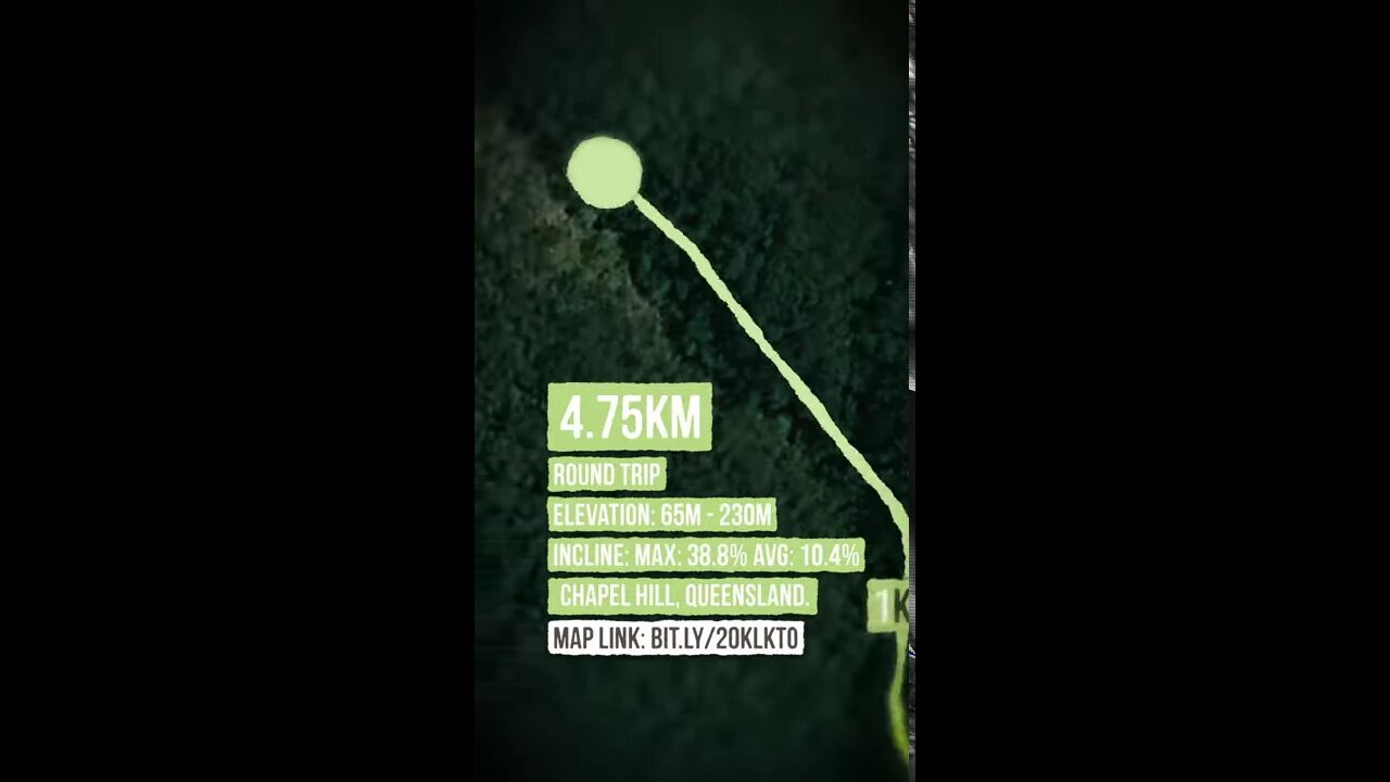
Powerful Owl Trail, Mount Coot-Tha - Hiking Map - Australia
4 years ago
#shorts #hiking #australia
4.75km (round trip)
Elevation: 65m - 230m
Incline: MAX: 38.8% AVG: 10.4%
Chapel Hill, Queensland
Map Link: http://bit.ly/2OklKto
Loading comments...
-
 1:35:44
Tucker Carlson
3 hours agoJohn Rich on Diddy, Demons, the Antichrist, How to Hear God, and His War on Child Predators
41.2K96 -
 1:09:52
The White House
5 hours agoPress Secretary Karoline Leavitt Briefs Members of the Media, Dec. 1, 2025
29.7K13 -
 1:18:25
The Quartering
3 hours agoBlack Friday Debt Bonanza, Youtube Bans Millions, South Park Roasts Bill Burr, MrBeast Outs Youtube
85.9K24 -
 1:07:23
DeVory Darkins
3 hours agoBREAKING: Minnesota State Employees SLAM Tim Walz for Massive $1 Billion Fraud Scheme
88.9K64 -
 3:27:36
Barry Cunningham
5 hours agoBREAKING NEWS: MELANIA TRUMP AND USHA VANCE CHRISTMAS EVENT AND KAROLINE LEAVITT PRESS CONFERENCE!
29.1K10 -
 42:07
42:07
Kurt Caz
3 days agoCatching Crooks in Paris Gone WRONG! (UNCENSORED) 🇫🇷
12.3K23 -
 1:19:45
TheSaltyCracker
2 hours agoSALTcast 12-01-25
27.3K64 -
![[Ep 803] 100% Moratorium on ALL Immigration! | Walz Defends Fraud | Obama’s Sedition](https://1a-1791.com/video/fww1/17/s8/1/e/6/D/E/e6DEz.0kob-small-Ep-803-100-Moratorium-on-AL.jpg) LIVE
LIVE
The Nunn Report - w/ Dan Nunn
1 hour ago[Ep 803] 100% Moratorium on ALL Immigration! | Walz Defends Fraud | Obama’s Sedition
116 watching -
 2:08:21
Side Scrollers Podcast
5 hours agoHasan Dog Joke Gets Streamer BANNED + Great Reset 100% CONFIRMED + More | Side Scrollers
32.1K5 -
 1:58:54
The Charlie Kirk Show
4 hours agoA Very Eventful Thanksgiving Weekend | Morris, Baris, Mac Donald | 12.1.2025
70.4K10