Satellite Photos from Donbas and Kharkiv Region Show MLRS, Artillery and Shelling - From 6th June
A little video here looking at a few satellite photos that were posted today. These were taken in the Donbas region, near Seveerodonetsk. They don’t show too much, but give an idea of Russia’s firing locations and deployment. The photos were shared by Maxar Technologies and were taken on the 6th June.
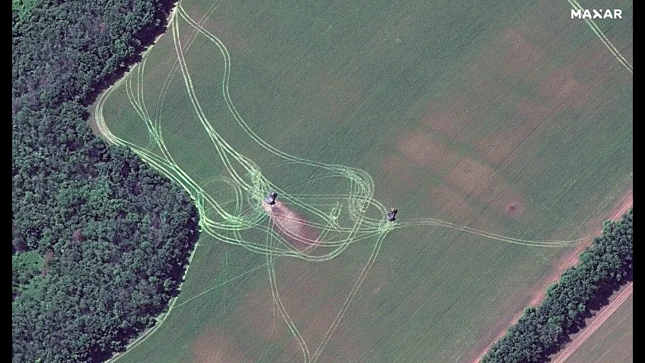
So, the first image here shows a pair of MLRS units. Maxar provided coordinates too, which lets us see the location of the units on Google Maps. So, they are located north of Severodonetsk. And approximately 10.78 kilometers north of the Mir Hotel in Severodonetsk.
The next image shows towed guns—again aimed at severodonetsk. There are three shown, surrounded by sandbags as protection for the crew from coutnerfire.
Also present, and now circled—a supply truck. Hidden in a cluster of trees, but still visible for satellites.
These artillery pieces are 8.66km north of Severodonetsk northern edge. But, their orientation appears to be aiming at the western side of the city. As shown here.
Finally, this image shows the impact of shelling at Dolyna. There are manyc raters from past barrages, and plumes of smoke from current and more recent impacts.
To the north, is this little structure here with a cell or radio tower. The building is damaged, but the tower remains.
On the road, in this image—there appears to be a truck or other vehicle. I can’t see any other vehicles or military emplacements in the area.
The coordinates given show that Dolyna is on the main road between Russian occupied Izyum and Ukrainian held Slovyansk—a key target for Russia.
Another image—this shows artillery fire along the Seversky Donets River. At a town called Bohorodychne. The bridge crossing the river is down. This town is not far from Dolyna.
This image shows fields absolutely riddled with artillery craters. No military vehicles present from what I cans ee—destroyed or otherwise. There is no incoming fire either shown. It could be that anything hit has already been carted away. The coordinates give its position here—west of Dolyna.
Finally, we have this image of a massive 40-meter crater in Dovhenke. This could be the result of this explosion from May 11 at an ammonium nitrate warehouse.
So, that’s it for the satellite images. Some quite interesting things shown. Nothing too ground breaking, but still worth a look. If you could like the video and subscribe, I would appreciate it.
-
 LIVE
LIVE
Benny Johnson
28 minutes agoBOMBSHELL: Confirmed Proof Biden FBI Identified Pipe Bomber in 2021, Cover Up EXPOSED In New Docs
2,066 watching -
 LIVE
LIVE
Graham Allen
1 hour agoTim Pool Is Going Underground Due To Safety! We ALL Will Soon! The Breaking Point Is Here!
2,404 watching -
 LIVE
LIVE
Matt Kohrs
13 hours agoLive Trading Market Open (Futures & Options) || The Matt Kohrs Show
585 watching -
 LIVE
LIVE
Badlands Media
5 hours agoBadlands Daily: 12/9/25
2,284 watching -
 LIVE
LIVE
Wendy Bell Radio
5 hours agoTrump is +5
7,093 watching -
 LIVE
LIVE
DML
31 minutes agoDML LIVE: Why We Are Losing Our Youth
203 watching -
 1:11:10
Chad Prather
12 hours agoThe Ripple Effect of a Changed Life: How God Uses Your Transformation
62.9K52 -
 1:40:06
MichaelBisping
10 hours agoBelieve You Me 660: UFC 323 Was A PROBLEM Ft. Chris "The Problem" Duncan
981 -
 8:03
8:03
Navy Media
4 days agoHow Aircraft Carriers Prepare 17,000 Meals A Day For 5,000 US Navy Sailors
3433 -
 LIVE
LIVE
LFA TV
13 hours agoLIVE & BREAKING NEWS! | TUESDAY 12/09/25
3,173 watching