Grizzly Flat North Trail / What's at the Bottom of the Middle Road?
Another stop on a bike ride to check out an old road I saw near the middle of the Grizzly Flat / North Trail in Upper Stevens Creek County Park. After checking out the barbed wire fence remains, tried to make it down to the bottom of the Branch D canyon.
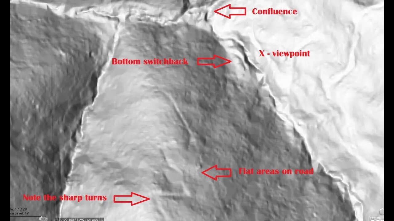
This road is very overgrown as it nears the bottom of the Branch D canyon due to the moist conditions. It seems there may have been an earlier road that made a large, sweeping turn and that may have slid out forcing a new road segment to be made. The newer road has very acute switchback turns that likely require backing down in a truck.
Also got to see the bottom of the old road that runs up the side of the ridge to Skyline Blvd. (Hwy. 35). I'll need to have a "live" hill shade map to explore more of this road as it's very faint in sections.
None of these roads appear on any maps. Grizzly Flat North Road first appears on the 1961 USGS topo map.
There appear to be at least 3 roads that come together at the bottom of the Branch D canyon. 2 of them seem to be quite old based on their minimal construction. Then this road seems more modern in terms of wider radius turns and that it joins up to an existing road. But then the question is, what was this built road for? Were the 2 older roads in the canyon still in use when this road was built? If not, then why did this road go down to the same area that the 2 old roads seem to meet up in? Maybe this road was abandoned when the county acquired this land for the county park in 1965.
It's about of a mile and 300 feet elevation drop (1.6km / 90m) from Grizzly Flat trail down to the bottom of the canyon on foot. Then it's a further 18.5 miles (30km) by bike on dirt and pavement to get here and back from home. Ends up being at least a 6 hour trip up here.
About the USGS HTMC:
https://www.usgs.gov/programs/national-geospatial-program/historical-topographic-maps-preserving-past
View/download maps on the TopoView site:
https://ngmdb.usgs.gov/topoview/
I used the 1897 Palo Alto quadrangle or the 1900 historical topo as listed in GaiaG:
https://www.gaiagps.com/
More to come...
Subscribe for more content like this
Comment, rate, share & click the bell icon
And as always, thanks for watching
#USGS #HillShade
-
 1:25:01
Misfits Mania
1 day ago $5.52 earnedMISFITS MANIA: Press Conference
12K7 -
 1:31:26
Graham Allen
2 hours agoLive From AMFEST 2025: Day 1
12.5K2 -
 1:56:43
Steven Crowder
4 hours agoLWC Christmas Special 2025 | Giving Back with Santa Crowder
200K77 -
 14:33
14:33
Robbi On The Record
3 hours ago $1.97 earnedNPC Girls & The Digital Dehumanization of Women
12.6K7 -
 53:25
53:25
Simply Bitcoin
1 day ago $0.64 earnedThe Bitcoin Crucible w/ Alex Stanczyk & Tomer Strolight - Episode 13
15K1 -
 59:21
59:21
The Rubin Report
2 hours agoIs This the Real Reason Bongino Is Leaving the FBI?
28.8K44 -
 LIVE
LIVE
LFA TV
15 hours agoLIVE & BREAKING NEWS! | THURSDAY 12/18/25
2,834 watching -
 LIVE
LIVE
The Mel K Show
2 hours agoMORNINGS WITH MEL K- America is Mad As Hell And We’re Not Going to Take it Anymore! - 12-18-25
830 watching -
 LIVE
LIVE
The Shannon Joy Show
3 hours ago🔥SJ LIVE Dec 18 - Exclusive With Peter Schiff On Trumpflation, The Affordability Crisis, AI Bubbles & Bitcoin Collapse. Will Metals Become The Global Hedge Against Financial Chaos?🔥
144 watching -
 45:19
45:19
Grant Stinchfield
1 hour agoKeystone Cops of the Ivy League... It Gets Worse Every Day as Brown Suspect Still on the Run!
1.72K9