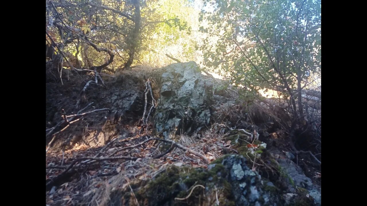
Rock Outcrop Along the Stevens Canyon Trail
An up close look at a bedrock outcrop on the North American side of the San Andreas fault and the Canyon Trail in Montebello Open Space Preserve.
Sorry about the video quality, my camera was having issues with the difficult lighting conditions.
The surface rocks along the stretch of the Canyon Trail where USGS shows the creek flowing are almost all angular. Aside from some minor rounding from decades of hoot, horse and bicycle travel, the rocks are all sharp and angular. This is in contrast to the well rounded rocks found in the bed of Stevens Creek. Also, many of the rocks in Waterwheel Creek proper are coated in Travertine from the minerals dissolved in that water.
Rock outcrop may be a Greenstone or similar type of metamorphosed basalt of the Franciscan Complex:
https://en.wikipedia.org/wiki/Franciscan_Complex
I was hoping to find a sedimentary rock to look at layering, but that type of rock is not as common on this side of the fault.
Geologic Analysis Of The Monte Bello Ridge Mountain Study Area paper:
https://fbdroch.com/book/environmental-geologic-analysis-of-the-monte-bello-ridge-mountain-study-area-santa-clara-county-california
From that paper:
"TECTONIC BLOCKS - Large angular to rounded, commonly elliptically shaped masses of relatively hard rocks surrounded by a clay-rich, sheared matrix. Occurs within shear zones and fault gouge. In the shear zones of the Franciscan rocks, these blocks range from "fist size" to masses more than one mile long."
USGS National Map Viewer w/ Hill Shade:
https://apps.nationalmap.gov/viewer/
About the USGS HTMC:
https://www.usgs.gov/programs/national-geospatial-program/historical-topographic-maps-preserving-past
View/download maps on the TopoView site:
https://ngmdb.usgs.gov/topoview/
Section of single track Canyon Trail built in 1990:
https://www.trailcenter.org/newsletter/2000/winter2000/winter2000-19f.htm
Future plan: I want to try to hike along the top of the ridge between the Canyon Trail and Stevens Creek between the Table Mtn. and Grizzly Flat trails. I'm hoping there might be some exposed sedimentary rock outcrops up there that might show if this block has been tilted in the past.
More to come...
Subscribe for more content like this
Comment, rate, share & click the bell icon
And as always, thanks for watching
#USGS #HillShade
-
 2:01:08
LFA TV
23 hours agoTHE RUMBLE RUNDOWN LIVE @9AM EST
71.5K5 -
 57:26
57:26
X22 Report
2 hours agoMr & Mrs X - The Food Industry Is Trying To Pull A Fast One On RFK Jr (MAHA), This Will Fail - EP 14
47K14 -
 1:06:36
Wendy Bell Radio
5 hours agoPet Talk With The Pet Doc
15.8K17 -
 30:58
30:58
SouthernbelleReacts
2 days ago $3.50 earnedWe Didn’t Expect That Ending… ‘Welcome to Derry’ S1 E1 Reaction
6.26K5 -
 13:51
13:51
True Crime | Unsolved Cases | Mysterious Stories
5 days ago $7.62 earned7 Real Life Heroes Caught on Camera (Remastered Audio)
13.8K1 -
 LIVE
LIVE
Total Horse Channel
11 hours ago2025 IRCHA Derby & Horse Show - November 1st
46 watching -
 4:19
4:19
PistonPop-TV
6 days ago $0.90 earnedThe 4E-FTE: Toyota’s Smallest Turbo Monster
11.2K -
 43:07
43:07
WanderingWithWine
5 days ago $0.66 earned5 Dreamy Italian Houses You Can Own Now! Homes for Sale in Italy
9.84K2 -
 LIVE
LIVE
Spartan
20 hours agoFirst playthrough of First Berserker Khazan
299 watching -
 28:01
28:01
Living Your Wellness Life
2 days agoTrain Your Hormones
12.5K