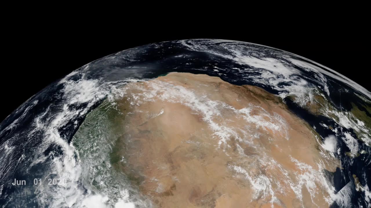
Godzilla Dust Strom। Nasa
In June 2020, a "Godzilla" dust plume travelled from the Sahara, the planet’s largest, hottest desert, across the Atlantic ocean to North America. Saharan dust plumes are a natural phenomenon and occur especially during the summertime, due to dust uplift from low level jets and haboobs. This particular event was nicknamed "Godzilla" dust plume, because of its huge extent and massive amount of dust transport - the most intense episode over the past two decades.
The data visualizations included on this webpage track the "Godzilla" dust plume by featuring near real-time VIIRS Corrected Reflectance (True Color) daily imagery for the month of June 2020. The first visualization listed on this webpage showcases the trans-Atlantic transport of the dust plume, while the second visualization showcases the formation of the dust plume as seen from West Africa.
The Sahara Desert is 3,600,000 square miles (9,200,000 square kilometers) of arid land stretched across the northern half of Africa, coming in just slightly smaller in size than the continental United States. Upwards of 60 million tons of its nutrient-laden sand and soil are lifted into the atmosphere each year, creating a massive layer of hot, dusty air that winds carry across the Atlantic to deliver those nutrients to the ocean and vegetation in South America and the Caribbean.
On its journey across the Atlantic, Saharan dust sprinkles into the ocean, feeding the marine life, and similarly plant life once it makes landfall. Minerals like iron and phosphorus in the dust act as a fertilizer for the Amazon rainforest, Earth’s largest and most biodiverse tropical forest, whose rains otherwise wash many of these valuable nutrients into the Amazon river basin.
Tracking and understanding dust plumes and their effects is critical, since dust intrusion also affects air quality. The “Godzilla” dust plume degraded the air quality in the Carribean Basin to the hazardous level and the dust intrusion into the U.S. exceeded the EPA air quality in about 40% of the stations in Southern U.S. Breathing in dust is particularly hazardous for children, the elderly, and those with respiratory conditions like asthma. Because of this, the Moderate Resolution Imaging Spectroradiometers (MODIS) on NASA's Terra and Aqua satellites, the National Oceanic and Atmospheric Administration (NOAA) GOES-16 (EAST) satellite, and the Visible Infrared Imaging Radiometer Suite (VIIRS) on the joint NASA/NOAA Suomi NPP satellite are employed to help detect dust plumes, so that at-risk communities could prepare for the potentially adverse health effects.
-
 LIVE
LIVE
Badlands Media
5 hours agoBadlands Daily: September 25, 2025
1,806 watching -
 LIVE
LIVE
Wendy Bell Radio
4 hours agoBLOOD ON THEIR HANDS (NEW)
7,702 watching -
 12:58
12:58
Degenerate Jay
2 hours agoMarvel's Wolverine Gameplay Looks Crazy!
581 -
 24:01
24:01
Bearing
2 hours agoWOKE LOSER Don Lemon MELTS DOWN on Piers Morgan 💥😂
6004 -
 1:30:36
Chicks On The Right
4 hours agoDallas ICE facility attack, Dems stoke violence, JD shines in latest speech, Tucker and the Jooos
36.7K9 -
 LIVE
LIVE
LFA TV
16 hours agoBREAKING NEWS ALL DAY! | THURSDAY 9/25/25
4,018 watching -
 1:27:45
Game On!
21 hours ago $0.95 earnedThursday Night Football SHOWDOWN! Seahawks vs Cardinals Divisional CLASH!
61.4K4 -
 28:53
28:53
Clownfish TV
1 day agoYouTube ADMITS They CENSORED Conservatives! What Else is Google Hiding?! | Clownfish TV
61.9K50 -
 40:15
40:15
NAG Daily
16 hours agoThe Rezendes Rundown Ep. 19 - Mad Bad Science
28.1K4 -
 31:57
31:57
Uncommon Sense In Current Times
19 hours ago $0.78 earnedThe DEI Housing Hoax | Dan Huff on Zoning, Manufactured Crisis & the War on Suburbs
33.4K3