Volcano Eruption from the International Space Station
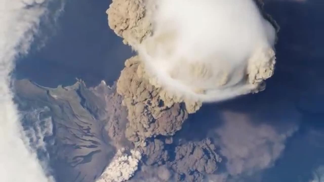
On June 12, 2009, a fortuitous orbit of the International Space Station (ISS) made it possible for an astronaut on board to capture Sarychev Volcano in the early stages of eruption. The volcano is located on the northwestern end of Matua Island, which is part of the Kuril Islands, a chain of 56 islands northeast of Japan. The eruption sent a plume of brown-colored ash and white steam rising into the atmosphere. The plume was so immense that it cast a large shadow on the island. Sarychev is one of the most active volcanoes in the Kuril Island chain. Prior to June 12, the last explosive eruption occurred in 1989, with eruptions in 1986, 1976, 1954, and 1946 also producing lava flows. Watch the video to see how the eruption looked from space. A fortuitous orbit of the International Space Station allowed the astronauts this striking view of Sarychev Volcano (Kuril Islands, northeast of Japan) in an early stage of eruption on June 12, 2009. Sarychev Peak is one of the most active volcanoes in the Kuril Island chain, and it is located on the northwestern end of Matua Island. For more info: http://earthobservatory.nasa.gov/IOTD/view.php?id=38985 http://eol.jsc.nasa.gov/ http://earthobservatory.nasa.gov/ This video can be freely shared and downloaded at https://svs.gsfc.nasa.gov/11446. While the video in its entirety can be shared without permission, the music and some individual imagery may have been obtained through permission and may not be excised or remixed in other products. Specific details on such imagery may be found here: https://svs.gsfc.nasa.gov/11446. For more information on NASA’s media guidelines, visitOn June 12, 2009, a fortuitous orbit of the International Space Station (ISS) made it possible for an astronaut on board to capture Sarychev Volcano in the early stages of eruption. The volcano is located on the northwestern end of Matua Island, which is part of the Kuril Islands, a chain of 56 islands northeast of Japan. The eruption sent a plume of brown-colored ash and white steam rising into the atmosphere. The plume was so immense that it cast a large shadow on the island. Sarychev is one of the most active volcanoes in the Kuril Island chain. Prior to June 12, the last explosive eruption occurred in 1989, with eruptions in 1986, 1976, 1954, and 1946 also producing lava flows. Watch the video to see how the eruption looked from space. A fortuitous orbit of the International Space Station allowed the astronauts this striking view of Sarychev Volcano (Kuril Islands, northeast of Japan) in an early stage of eruption on June 12, 2009. Sarychev Peak is one of the most active volcanoes in the Kuril Island chain, and it is located on the northwestern end of Matua Island. For more info: http://earthobservatory.nasa.gov/IOTD/view.php?id=38985 http://eol.jsc.nasa.gov/ http://earthobservatory.nasa.gov/ This video can be freely shared and downloaded at https://svs.gsfc.nasa.gov/11446. While the video in its entirety can be shared without permission, the music and some individual imagery may have been obtained through permission and may not be excised or remixed in other products. Specific details on such imagery may be found here: https://svs.gsfc.nasa.gov/11446. For more information on NASA’s media guidelines, visitOn June 12, 2009, a fortuitous orbit of the International Space Station (ISS) made it possible for an astronaut on board to capture Sarychev Volcano in the early stages of eruption. The volcano is located on the northwestern end of Matua Island, which is part of the Kuril Islands, a chain of 56 islands northeast of Japan. The eruption sent a plume of brown-colored ash and white steam rising into the atmosphere. The plume was so immense that it cast a large shadow on the island. Sarychev is one of the most active volcanoes in the Kuril Island chain. Prior to June 12, the last explosive eruption occurred in 1989, with eruptions in 1986, 1976, 1954, and 1946 also producing lava flows. Watch the video to see how the eruption looked from space. A fortuitous orbit of the International Space Station allowed the astronauts this striking view of Sarychev Volcano (Kuril Islands, northeast of Japan) in an early stage of eruption on June 12, 2009. Sarychev Peak is one of the most active volcanoes in the Kuril Island chain, and it is located on the northwestern end of Matua Island. For more info: http://earthobservatory.nasa.gov/IOTD/view.php?id=38985 http://eol.jsc.nasa.gov/ http://earthobservatory.nasa.gov/ This video can be freely shared and downloaded at https://svs.gsfc.nasa.gov/11446. While the video in its entirety can be shared without permission, the music and some individual imagery may have been obtained through permission and may not be excised or remixed in other products. Specific details on such imagery may be found here: https://svs.gsfc.nasa.gov/11446. For more information on NASA’s media guidelines, visitOn June 12, 2009, a fortuitous orbit of the International Space Station (ISS) made it possible for an astronaut on board to capture Sarychev Volcano in the early stages of eruption. The volcano is located on the northwestern end of Matua Island, which is part of the Kuril Islands, a chain of 56 islands northeast of Japan. The eruption sent a plume of brown-colored ash and white steam rising into the atmosphere. The plume was so immense that it cast a large shadow on the island. Sarychev is one of the most active volcanoes in the Kuril Island chain. Prior to June 12, the last explosive eruption occurred in 1989, with eruptions in 1986, 1976, 1954, and 1946 also producing lava flows. Watch the video to see how the eruption looked from space. A fortuitous orbit of the International Space Station allowed the astronauts this striking view of Sarychev Volcano (Kuril Islands, northeast of Japan) in an early stage of eruption on June 12, 2009. Sarychev Peak is one of the most active volcanoes in the Kuril Island chain, and it is located on the northwestern end of Matua Island. For more info: http://earthobservatory.nasa.gov/IOTD/view.php?id=38985 http://eol.jsc.nasa.gov/ http://earthobservatory.nasa.gov/ This video can be freely shared and downloaded at https://svs.gsfc.nasa.gov/11446. While the video in its entirety can be shared without permission, the music and some individual imagery may have been obtained through permission and may not be excised or remixed in other products. Specific details on such imagery may be found here: https://svs.gsfc.nasa.gov/11446. For more information on NASA’s media guidelines, visitOn June 12, 2009, a fortuitous orbit of the International Space Station (ISS) made it possible for an astronaut on board to capture Sarychev Volcano in the early stages of eruption. The volcano is located on the northwestern end of Matua Island, which is part of the Kuril Islands, a chain of 56 islands northeast of Japan. The eruption sent a plume of brown-colored ash and white steam rising into the atmosphere. The plume was so immense that it cast a large shadow on the island. Sarychev is one of the most active volcanoes in the Kuril Island chain. Prior to June 12, the last explosive eruption occurred in 1989, with eruptions in 1986, 1976, 1954, and 1946 also producing lava flows. Watch the video to see how the eruption looked from space. A fortuitous orbit of the International Space Station allowed the astronauts this striking view of Sarychev Volcano (Kuril Islands, northeast of Japan) in an early stage of eruption on June 12, 2009. Sarychev Peak is one of the most active volcanoes in the Kuril Island chain, and it is located on the northwestern end of Matua Island. For more info: http://earthobservatory.nasa.gov/IOTD/view.php?id=38985 http://eol.jsc.nasa.gov/ http://earthobservatory.nasa.gov/ This video can be freely shared and downloaded at https://svs.gsfc.nasa.gov/11446. While the video in its entirety can be shared without permission, the music and some individual imagery may have been obtained through permission and may not be excised or remixed in other products. Specific details on such imagery may be found here: https://svs.gsfc.nasa.gov/11446. For more information on NASA’s media guidelines, visitOn June 12, 2009, a fortuitous orbit of the International Space Station (ISS) made it possible for an astronaut on board to capture Sarychev Volcano in the early stages of eruption. The volcano is located on the northwestern end of Matua Island, which is part of the Kuril Islands, a chain of 56 islands northeast of Japan. The eruption sent a plume of brown-colored ash and white steam rising into the atmosphere. The plume was so immense that it cast a large shadow on the island. Sarychev is one of the most active volcanoes in the Kuril Island chain. Prior to June 12, the last explosive eruption occurred in 1989, with eruptions in 1986, 1976, 1954, and 1946 also producing lava flows. Watch the video to see how the eruption looked from space. A fortuitous orbit of the International Space Station allowed the astronauts this striking view of Sarychev Volcano (Kuril Islands, northeast of Japan) in an early stage of eruption on June 12, 2009. Sarychev Peak is one of the most active volcanoes in the Kuril Island chain, and it is located on the northwestern end of Matua Island. For more info: http://earthobservatory.nasa.gov/IOTD/view.php?id=38985 http://eol.jsc.nasa.gov/ http://earthobservatory.nasa.gov/ This video can be freely shared and downloaded at https://svs.gsfc.nasa.gov/11446. While the video in its entirety can be shared without permission, the music and some individual imagery may have been obtained through permission and may not be excised or remixed in other products. Specific details on such imagery may be found here: https://svs.gsfc.nasa.gov/11446. For more information on NASA’s media guidelines, visitOn June 12, 2009, a fortuitous orbit of the International Space Station (ISS) made it possible for an astronaut on board to capture Sarychev Volcano in the early stages of eruption. The volcano is located on the northwestern end of Matua Island, which is part of the Kuril Islands, a chain of 56 islands northeast of Japan. The eruption sent a plume of brown-colored ash and white steam rising into the atmosphere. The plume was so immense that it cast a large shadow on the island. Sarychev is one of the most active volcanoes in the Kuril Island chain. Prior to June 12, the last explosive eruption occurred in 1989, with eruptions in 1986, 1976, 1954, and 1946 also producing lava flows. Watch the video to see how the eruption looked from space. A fortuitous orbit of the International Space Station allowed the astronauts this striking view of Sarychev Volcano (Kuril Islands, northeast of Japan) in an early stage of eruption on June 12, 2009. Sarychev Peak is one of the most active volcanoes in the Kuril Island chain, and it is located on the northwestern end of Matua Island. For more info: http://earthobservatory.nasa.gov/IOTD/view.php?id=38985 http://eol.jsc.nasa.gov/ http://earthobservatory.nasa.gov/ This video can be freely shared and downloaded at https://svs.gsfc.nasa.gov/11446. While the video in its entirety can be shared without permission, the music and some individual imagery may have been obtained through permission and may not be excised or remixed in other products. Specific details on such imagery may be found here: https://svs.gsfc.nasa.gov/11446. For more information on NASA’s media guidelines, visitOn June 12, 2009, a fortuitous orbit of the International Space Station (ISS) made it possible for an astronaut on board to capture Sarychev Volcano in the early stages of eruption. The volcano is located on the northwestern end of Matua Island, which is part of the Kuril Islands, a chain of 56 islands northeast of Japan. The eruption sent a plume of brown-colored ash and white steam rising into the atmosphere. The plume was so immense that it cast a large shadow on the island. Sarychev is one of the most active volcanoes in the Kuril Island chain. Prior to June 12, the last explosive eruption occurred in 1989, with eruptions in 1986, 1976, 1954, and 1946 also producing lava flows. Watch the video to see how the eruption looked from space. A fortuitous orbit of the International Space Station allowed the astronauts this striking view of Sarychev Volcano (Kuril Islands, northeast of Japan) in an early stage of eruption on June 12, 2009. Sarychev Peak is one of the most active volcanoes in the Kuril Island chain, and it is located on the northwestern end of Matua Island. For more info: http://earthobservatory.nasa.gov/IOTD/view.php?id=38985 http://eol.jsc.nasa.gov/ http://earthobservatory.nasa.gov/ This video can be freely shared and downloaded at https://svs.gsfc.nasa.gov/11446. While the video in its entirety can be shared without permission, the music and some individual imagery may have been obtained through permission and may not be excised or remixed in other products. Specific details on such imagery may be found here: https://svs.gsfc.nasa.gov/11446. For more information on NASA’s media guidelines, visitOn June 12, 2009, a fortuitous orbit of the International Space Station (ISS) made it possible for an astronaut on board to capture Sarychev Volcano in the early stages of eruption. The volcano is located on the northwestern end of Matua Island, which is part of the Kuril Islands, a chain of 56 islands northeast of Japan. The eruption sent a plume of brown-colored ash and white steam rising into the atmosphere. The plume was so immense that it cast a large shadow on the island. Sarychev is one of the most active volcanoes in the Kuril Island chain. Prior to June 12, the last explosive eruption occurred in 1989, with eruptions in 1986, 1976, 1954, and 1946 also producing lava flows. Watch the video to see how the eruption looked from space. A fortuitous orbit of the International Space Station allowed the astronauts this striking view of Sarychev Volcano (Kuril Islands, northeast of Japan) in an early stage of eruption on June 12, 2009. Sarychev Peak is one of the most active volcanoes in the Kuril Island chain, and it is located on the northwestern end of Matua Island. For more info: http://earthobservatory.nasa.gov/IOTD/view.php?id=38985 http://eol.jsc.nasa.gov/ http://earthobservatory.nasa.gov/ This video can be freely shared and downloaded at https://svs.gsfc.nasa.gov/11446. While the video in its entirety can be shared without permission, the music and some individual imagery may have been obtained through permission and may not be excised or remixed in other products. Specific details on such imagery may be found here: https://svs.gsfc.nasa.gov/11446. For more information on NASA’s media guidelines, visitOn June 12, 2009, a fortuitous orbit of the International Space Station (ISS) made it possible for an astronaut on board to capture Sarychev Volcano in the early stages of eruption. The volcano is located on the northwestern end of Matua Island, which is part of the Kuril Islands, a chain of 56 islands northeast of Japan. The eruption sent a plume of brown-colored ash and white steam rising into the atmosphere. The plume was so immense that it cast a large shadow on the island. Sarychev is one of the most active volcanoes in the Kuril Island chain. Prior to June 12, the last explosive eruption occurred in 1989, with eruptions in 1986, 1976, 1954, and 1946 also producing lava flows. Watch the video to see how the eruption looked from space. A fortuitous orbit of the International Space Station allowed the astronauts this striking view of Sarychev Volcano (Kuril Islands, northeast of Japan) in an early stage of eruption on June 12, 2009. Sarychev Peak is one of the most active volcanoes in the Kuril Island chain, and it is located on the northwestern end of Matua Island. For more info: http://earthobservatory.nasa.gov/IOTD/view.php?id=38985 http://eol.jsc.nasa.gov/ http://earthobservatory.nasa.gov/ This video can be freely shared and downloaded at https://svs.gsfc.nasa.gov/11446. While the video in its entirety can be shared without permission, the music and some individual imagery may have been obtained through permission and may not be excised or remixed in other products. Specific details on such imagery may be found here: https://svs.gsfc.nasa.gov/11446. For more information on NASA’s media guidelines, visitOn June 12, 2009, a fortuitous orbit of the International Space Station (ISS) made it possible for an astronaut on board to capture Sarychev Volcano in the early stages of eruption. The volcano is located on the northwestern end of Matua Island, which is part of the Kuril Islands, a chain of 56 islands northeast of Japan. The eruption sent a plume of brown-colored ash and white steam rising into the atmosphere. The plume was so immense that it cast a large shadow on the island. Sarychev is one of the most active volcanoes in the Kuril Island chain. Prior to June 12, the last explosive eruption occurred in 1989, with eruptions in 1986, 1976, 1954, and 1946 also producing lava flows. Watch the video to see how the eruption looked from space. A fortuitous orbit of the International Space Station allowed the astronauts this striking view of Sarychev Volcano (Kuril Islands, northeast of Japan) in an early stage of eruption on June 12, 2009. Sarychev Peak is one of the most active volcanoes in the Kuril Island chain, and it is located on the northwestern end of Matua Island. For more info: http://earthobservatory.nasa.gov/IOTD/view.php?id=38985 http://eol.jsc.nasa.gov/ http://earthobservatory.nasa.gov/ This video can be freely shared and downloaded at https://svs.gsfc.nasa.gov/11446. While the video in its entirety can be shared without permission, the music and some individual imagery may have been obtained through permission and may not be excised or remixed in other products. Specific details on such imagery may be found here: https://svs.gsfc.nasa.gov/11446. For more information on NASA’s media guidelines, visitOn June 12, 2009, a fortuitous orbit of the International Space Station (ISS) made it possible for an astronaut on board to capture Sarychev Volcano in the early stages of eruption. The volcano is located on the northwestern end of Matua Island, which is part of the Kuril Islands, a chain of 56 islands northeast of Japan. The eruption sent a plume of brown-colored ash and white steam rising into the atmosphere. The plume was so immense that it cast a large shadow on the island. Sarychev is one of the most active volcanoes in the Kuril Island chain. Prior to June 12, the last explosive eruption occurred in 1989, with eruptions in 1986, 1976, 1954, and 1946 also producing lava flows. Watch the video to see how the eruption looked from space. A fortuitous orbit of the International Space Station allowed the astronauts this striking view of Sarychev Volcano (Kuril Islands, northeast of Japan) in an early stage of eruption on June 12, 2009. Sarychev Peak is one of the most active volcanoes in the Kuril Island chain, and it is located on the northwestern end of Matua Island. For more info: http://earthobservatory.nasa.gov/IOTD/view.php?id=38985 http://eol.jsc.nasa.gov/ http://earthobservatory.nasa.gov/ This video can be freely shared and downloaded at https://svs.gsfc.nasa.gov/11446. While the video in its entirety can be shared without permission, the music and some individual imagery may have been obtained through permission and may not be excised or remixed in other products. Specific details on such imagery may be found here: https://svs.gsfc.nasa.gov/11446. For more information on NASA’s media guidelines, visitOn June 12, 2009, a fortuitous orbit of the International Space Station (ISS) made it possible for an astronaut on board to capture Sarychev Volcano in the early stages of eruption. The volcano is located on the northwestern end of Matua Island, which is part of the Kuril Islands, a chain of 56 islands northeast of Japan. The eruption sent a plume of brown-colored ash and white steam rising into the atmosphere. The plume was so immense that it cast a large shadow on the island. Sarychev is one of the most active volcanoes in the Kuril Island chain. Prior to June 12, the last explosive eruption occurred in 1989, with eruptions in 1986, 1976, 1954, and 1946 also producing lava flows. Watch the video to see how the eruption looked from space. A fortuitous orbit of the International Space Station allowed the astronauts this striking view of Sarychev Volcano (Kuril Islands, northeast of Japan) in an early stage of eruption on June 12, 2009. Sarychev Peak is one of the most active volcanoes in the Kuril Island chain, and it is located on the northwestern end of Matua Island. For more info: http://earthobservatory.nasa.gov/IOTD/view.php?id=38985 http://eol.jsc.nasa.gov/ http://earthobservatory.nasa.gov/ This video can be freely shared and downloaded at https://svs.gsfc.nasa.gov/11446. While the video in its entirety can be shared without permission, the music and some individual imagery may have been obtained through permission and may not be excised or remixed in other products. Specific details on such imagery may be found here: https://svs.gsfc.nasa.gov/11446. For more information on NASA’s media guidelines, visitOn June 12, 2009, a fortuitous orbit of the International Space Station (ISS) made it possible for an astronaut on board to capture Sarychev Volcano in the early stages of eruption. The volcano is located on the northwestern end of Matua Island, which is part of the Kuril Islands, a chain of 56 islands northeast of Japan. The eruption sent a plume of brown-colored ash and white steam rising into the atmosphere. The plume was so immense that it cast a large shadow on the island. Sarychev is one of the most active volcanoes in the Kuril Island chain. Prior to June 12, the last explosive eruption occurred in 1989, with eruptions in 1986, 1976, 1954, and 1946 also producing lava flows. Watch the video to see how the eruption looked from space. A fortuitous orbit of the International Space Station allowed the astronauts this striking view of Sarychev Volcano (Kuril Islands, northeast of Japan) in an early stage of eruption on June 12, 2009. Sarychev Peak is one of the most active volcanoes in the Kuril Island chain, and it is located on the northwestern end of Matua Island. For more info: http://earthobservatory.nasa.gov/IOTD/view.php?id=38985 http://eol.jsc.nasa.gov/ http://earthobservatory.nasa.gov/ This video can be freely shared and downloaded at https://svs.gsfc.nasa.gov/11446. While the video in its entirety can be shared without permission, the music and some individual imagery may have been obtained through permission and may not be excised or remixed in other products. Specific details on such imagery may be found here: https://svs.gsfc.nasa.gov/11446. For more information on NASA’s media guidelines, visit
-
 15:57
15:57
Robbi On The Record
1 day ago $6.30 earnedTranshumanism: Are Humans Becoming Obsolete? Neuralink & CRISPR explained
37.2K13 -
 2:22:21
TheSaltyCracker
7 hours agoICE Smashing Antifa ReeEEStream 9-26-25
107K163 -

SpartakusLIVE
8 hours ago#1 HERO of the PEOPLE || Ending the Week with FUN, WINS, and LAUGHS
76K -
 3:52:22
SynthTrax & DJ Cheezus Livestreams
18 hours agoFriday Night Synthwave 80s 90s Electronica and more DJ MIX Livestream THE FLOATING WORLD / Variety Music Edition
35K3 -
 LIVE
LIVE
Eternal_Spartan
14 hours ago🟢 Eternal Spartan Plays Destiny 2 | FPS Friday | | USMC Veteran
574 watching -
 2:04:11
MattMorseTV
8 hours ago $19.80 earned🔴The UK just hit ROCK BOTTOM.🔴
70.6K163 -
 5:37:54
iCheapshot
6 hours ago $4.01 earnedBack From Vacation! | Checking Out Skate Maybe Some Boarderlands 4
58.8K1 -
 3:08:37
Jorba4
5 hours ago🔴Live-Jorba4- Borderlands w/ The TRIBE
48.6K -
 54:43
54:43
Glenn Greenwald
9 hours agoGlenn Reacts to Netanyahu's UN Speech; PLUS: Q&A on Trump's Russia/Ukraine Policy, the Tom Homan Investigation, and More | SYSTEM UPDATE #522
92.1K49 -
 43:54
43:54
Donald Trump Jr.
8 hours agoJames and the Giant Breach, Plus Explosive J6 Revelations | TRIGGERED Ep.277
171K188