Volcano Eruption from the International Space Station
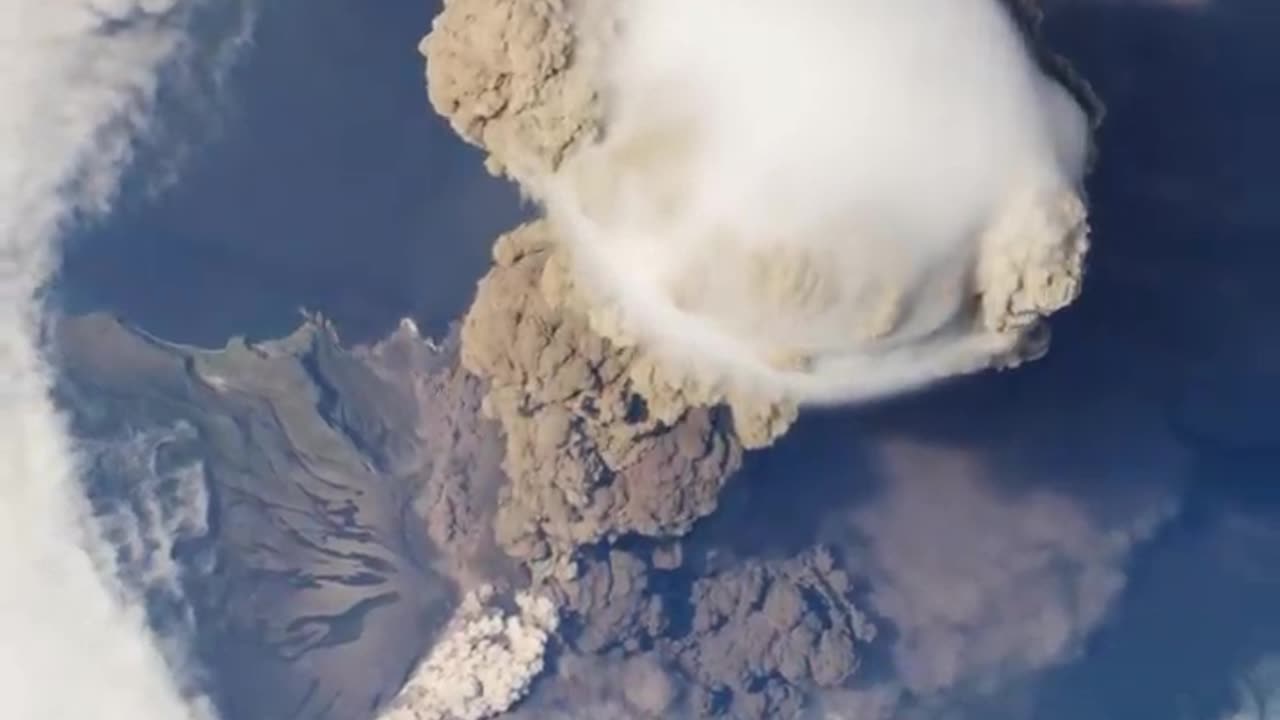
On June 12, 2009, a fortuitous orbit of the International Space Station (ISS) made it possible for an astronaut on board to capture Sarychev Volcano in the early stages of eruption. The volcano is located on the northwestern end of Matua Island, which is part of the Kuril Islands, a chain of 56 islands northeast of Japan. The eruption sent a plume of brown-colored ash and white steam rising into the atmosphere. The plume was so immense that it cast a large shadow on the island. Sarychev is one of the most active volcanoes in the Kuril Island chain. Prior to June 12, the last explosive eruption occurred in 1989, with eruptions in 1986, 1976, 1954, and 1946 also producing lava flows. Watch the video to see how the eruption looked from space. A fortuitous orbit of the International Space Station allowed the astronauts this striking view of Sarychev Volcano (Kuril Islands, northeast of Japan) in an early stage of eruption on June 12, 2009. Sarychev Peak is one of the most active volcanoes in the Kuril Island chain, and it is located on the northwestern end of Matua Island. For more info: http://earthobservatory.nasa.gov/IOTD/view.php?id=38985 http://eol.jsc.nasa.gov/ http://earthobservatory.nasa.gov/ This video can be freely shared and downloaded at https://svs.gsfc.nasa.gov/11446. While the video in its entirety can be shared without permission, the music and some individual imagery may have been obtained through permission and may not be excised or remixed in other products. Specific details on such imagery may be found here: https://svs.gsfc.nasa.gov/11446. For more information on NASA’s media guidelines, visitOn June 12, 2009, a fortuitous orbit of the International Space Station (ISS) made it possible for an astronaut on board to capture Sarychev Volcano in the early stages of eruption. The volcano is located on the northwestern end of Matua Island, which is part of the Kuril Islands, a chain of 56 islands northeast of Japan. The eruption sent a plume of brown-colored ash and white steam rising into the atmosphere. The plume was so immense that it cast a large shadow on the island. Sarychev is one of the most active volcanoes in the Kuril Island chain. Prior to June 12, the last explosive eruption occurred in 1989, with eruptions in 1986, 1976, 1954, and 1946 also producing lava flows. Watch the video to see how the eruption looked from space. A fortuitous orbit of the International Space Station allowed the astronauts this striking view of Sarychev Volcano (Kuril Islands, northeast of Japan) in an early stage of eruption on June 12, 2009. Sarychev Peak is one of the most active volcanoes in the Kuril Island chain, and it is located on the northwestern end of Matua Island. For more info: http://earthobservatory.nasa.gov/IOTD/view.php?id=38985 http://eol.jsc.nasa.gov/ http://earthobservatory.nasa.gov/ This video can be freely shared and downloaded at https://svs.gsfc.nasa.gov/11446. While the video in its entirety can be shared without permission, the music and some individual imagery may have been obtained through permission and may not be excised or remixed in other products. Specific details on such imagery may be found here: https://svs.gsfc.nasa.gov/11446. For more information on NASA’s media guidelines, visitOn June 12, 2009, a fortuitous orbit of the International Space Station (ISS) made it possible for an astronaut on board to capture Sarychev Volcano in the early stages of eruption. The volcano is located on the northwestern end of Matua Island, which is part of the Kuril Islands, a chain of 56 islands northeast of Japan. The eruption sent a plume of brown-colored ash and white steam rising into the atmosphere. The plume was so immense that it cast a large shadow on the island. Sarychev is one of the most active volcanoes in the Kuril Island chain. Prior to June 12, the last explosive eruption occurred in 1989, with eruptions in 1986, 1976, 1954, and 1946 also producing lava flows. Watch the video to see how the eruption looked from space. A fortuitous orbit of the International Space Station allowed the astronauts this striking view of Sarychev Volcano (Kuril Islands, northeast of Japan) in an early stage of eruption on June 12, 2009. Sarychev Peak is one of the most active volcanoes in the Kuril Island chain, and it is located on the northwestern end of Matua Island. For more info: http://earthobservatory.nasa.gov/IOTD/view.php?id=38985 http://eol.jsc.nasa.gov/ http://earthobservatory.nasa.gov/ This video can be freely shared and downloaded at https://svs.gsfc.nasa.gov/11446. While the video in its entirety can be shared without permission, the music and some individual imagery may have been obtained through permission and may not be excised or remixed in other products. Specific details on such imagery may be found here: https://svs.gsfc.nasa.gov/11446. For more information on NASA’s media guidelines, visitOn June 12, 2009, a fortuitous orbit of the International Space Station (ISS) made it possible for an astronaut on board to capture Sarychev Volcano in the early stages of eruption. The volcano is located on the northwestern end of Matua Island, which is part of the Kuril Islands, a chain of 56 islands northeast of Japan. The eruption sent a plume of brown-colored ash and white steam rising into the atmosphere. The plume was so immense that it cast a large shadow on the island. Sarychev is one of the most active volcanoes in the Kuril Island chain. Prior to June 12, the last explosive eruption occurred in 1989, with eruptions in 1986, 1976, 1954, and 1946 also producing lava flows. Watch the video to see how the eruption looked from space. A fortuitous orbit of the International Space Station allowed the astronauts this striking view of Sarychev Volcano (Kuril Islands, northeast of Japan) in an early stage of eruption on June 12, 2009. Sarychev Peak is one of the most active volcanoes in the Kuril Island chain, and it is located on the northwestern end of Matua Island. For more info: http://earthobservatory.nasa.gov/IOTD/view.php?id=38985 http://eol.jsc.nasa.gov/ http://earthobservatory.nasa.gov/ This video can be freely shared and downloaded at https://svs.gsfc.nasa.gov/11446. While the video in its entirety can be shared without permission, the music and some individual imagery may have been obtained through permission and may not be excised or remixed in other products. Specific details on such imagery may be found here: https://svs.gsfc.nasa.gov/11446. For more information on NASA’s media guidelines, visitOn June 12, 2009, a fortuitous orbit of the International Space Station (ISS) made it possible for an astronaut on board to capture Sarychev Volcano in the early stages of eruption. The volcano is located on the northwestern end of Matua Island, which is part of the Kuril Islands, a chain of 56 islands northeast of Japan. The eruption sent a plume of brown-colored ash and white steam rising into the atmosphere. The plume was so immense that it cast a large shadow on the island. Sarychev is one of the most active volcanoes in the Kuril Island chain. Prior to June 12, the last explosive eruption occurred in 1989, with eruptions in 1986, 1976, 1954, and 1946 also producing lava flows. Watch the video to see how the eruption looked from space. A fortuitous orbit of the International Space Station allowed the astronauts this striking view of Sarychev Volcano (Kuril Islands, northeast of Japan) in an early stage of eruption on June 12, 2009. Sarychev Peak is one of the most active volcanoes in the Kuril Island chain, and it is located on the northwestern end of Matua Island. For more info: http://earthobservatory.nasa.gov/IOTD/view.php?id=38985 http://eol.jsc.nasa.gov/ http://earthobservatory.nasa.gov/ This video can be freely shared and downloaded at https://svs.gsfc.nasa.gov/11446. While the video in its entirety can be shared without permission, the music and some individual imagery may have been obtained through permission and may not be excised or remixed in other products. Specific details on such imagery may be found here: https://svs.gsfc.nasa.gov/11446. For more information on NASA’s media guidelines, visitOn June 12, 2009, a fortuitous orbit of the International Space Station (ISS) made it possible for an astronaut on board to capture Sarychev Volcano in the early stages of eruption. The volcano is located on the northwestern end of Matua Island, which is part of the Kuril Islands, a chain of 56 islands northeast of Japan. The eruption sent a plume of brown-colored ash and white steam rising into the atmosphere. The plume was so immense that it cast a large shadow on the island. Sarychev is one of the most active volcanoes in the Kuril Island chain. Prior to June 12, the last explosive eruption occurred in 1989, with eruptions in 1986, 1976, 1954, and 1946 also producing lava flows. Watch the video to see how the eruption looked from space. A fortuitous orbit of the International Space Station allowed the astronauts this striking view of Sarychev Volcano (Kuril Islands, northeast of Japan) in an early stage of eruption on June 12, 2009. Sarychev Peak is one of the most active volcanoes in the Kuril Island chain, and it is located on the northwestern end of Matua Island. For more info: http://earthobservatory.nasa.gov/IOTD/view.php?id=38985 http://eol.jsc.nasa.gov/ http://earthobservatory.nasa.gov/ This video can be freely shared and downloaded at https://svs.gsfc.nasa.gov/11446. While the video in its entirety can be shared without permission, the music and some individual imagery may have been obtained through permission and may not be excised or remixed in other products. Specific details on such imagery may be found here: https://svs.gsfc.nasa.gov/11446. For more information on NASA’s media guidelines, visitOn June 12, 2009, a fortuitous orbit of the International Space Station (ISS) made it possible for an astronaut on board to capture Sarychev Volcano in the early stages of eruption. The volcano is located on the northwestern end of Matua Island, which is part of the Kuril Islands, a chain of 56 islands northeast of Japan. The eruption sent a plume of brown-colored ash and white steam rising into the atmosphere. The plume was so immense that it cast a large shadow on the island. Sarychev is one of the most active volcanoes in the Kuril Island chain. Prior to June 12, the last explosive eruption occurred in 1989, with eruptions in 1986, 1976, 1954, and 1946 also producing lava flows. Watch the video to see how the eruption looked from space. A fortuitous orbit of the International Space Station allowed the astronauts this striking view of Sarychev Volcano (Kuril Islands, northeast of Japan) in an early stage of eruption on June 12, 2009. Sarychev Peak is one of the most active volcanoes in the Kuril Island chain, and it is located on the northwestern end of Matua Island. For more info: http://earthobservatory.nasa.gov/IOTD/view.php?id=38985 http://eol.jsc.nasa.gov/ http://earthobservatory.nasa.gov/ This video can be freely shared and downloaded at https://svs.gsfc.nasa.gov/11446. While the video in its entirety can be shared without permission, the music and some individual imagery may have been obtained through permission and may not be excised or remixed in other products. Specific details on such imagery may be found here: https://svs.gsfc.nasa.gov/11446. For more information on NASA’s media guidelines, visitOn June 12, 2009, a fortuitous orbit of the International Space Station (ISS) made it possible for an astronaut on board to capture Sarychev Volcano in the early stages of eruption. The volcano is located on the northwestern end of Matua Island, which is part of the Kuril Islands, a chain of 56 islands northeast of Japan. The eruption sent a plume of brown-colored ash and white steam rising into the atmosphere. The plume was so immense that it cast a large shadow on the island. Sarychev is one of the most active volcanoes in the Kuril Island chain. Prior to June 12, the last explosive eruption occurred in 1989, with eruptions in 1986, 1976, 1954, and 1946 also producing lava flows. Watch the video to see how the eruption looked from space. A fortuitous orbit of the International Space Station allowed the astronauts this striking view of Sarychev Volcano (Kuril Islands, northeast of Japan) in an early stage of eruption on June 12, 2009. Sarychev Peak is one of the most active volcanoes in the Kuril Island chain, and it is located on the northwestern end of Matua Island. For more info: http://earthobservatory.nasa.gov/IOTD/view.php?id=38985 http://eol.jsc.nasa.gov/ http://earthobservatory.nasa.gov/ This video can be freely shared and downloaded at https://svs.gsfc.nasa.gov/11446. While the video in its entirety can be shared without permission, the music and some individual imagery may have been obtained through permission and may not be excised or remixed in other products. Specific details on such imagery may be found here: https://svs.gsfc.nasa.gov/11446. For more information on NASA’s media guidelines, visitOn June 12, 2009, a fortuitous orbit of the International Space Station (ISS) made it possible for an astronaut on board to capture Sarychev Volcano in the early stages of eruption. The volcano is located on the northwestern end of Matua Island, which is part of the Kuril Islands, a chain of 56 islands northeast of Japan. The eruption sent a plume of brown-colored ash and white steam rising into the atmosphere. The plume was so immense that it cast a large shadow on the island. Sarychev is one of the most active volcanoes in the Kuril Island chain. Prior to June 12, the last explosive eruption occurred in 1989, with eruptions in 1986, 1976, 1954, and 1946 also producing lava flows. Watch the video to see how the eruption looked from space. A fortuitous orbit of the International Space Station allowed the astronauts this striking view of Sarychev Volcano (Kuril Islands, northeast of Japan) in an early stage of eruption on June 12, 2009. Sarychev Peak is one of the most active volcanoes in the Kuril Island chain, and it is located on the northwestern end of Matua Island. For more info: http://earthobservatory.nasa.gov/IOTD/view.php?id=38985 http://eol.jsc.nasa.gov/ http://earthobservatory.nasa.gov/ This video can be freely shared and downloaded at https://svs.gsfc.nasa.gov/11446. While the video in its entirety can be shared without permission, the music and some individual imagery may have been obtained through permission and may not be excised or remixed in other products. Specific details on such imagery may be found here: https://svs.gsfc.nasa.gov/11446. For more information on NASA’s media guidelines, visitOn June 12, 2009, a fortuitous orbit of the International Space Station (ISS) made it possible for an astronaut on board to capture Sarychev Volcano in the early stages of eruption. The volcano is located on the northwestern end of Matua Island, which is part of the Kuril Islands, a chain of 56 islands northeast of Japan. The eruption sent a plume of brown-colored ash and white steam rising into the atmosphere. The plume was so immense that it cast a large shadow on the island. Sarychev is one of the most active volcanoes in the Kuril Island chain. Prior to June 12, the last explosive eruption occurred in 1989, with eruptions in 1986, 1976, 1954, and 1946 also producing lava flows. Watch the video to see how the eruption looked from space. A fortuitous orbit of the International Space Station allowed the astronauts this striking view of Sarychev Volcano (Kuril Islands, northeast of Japan) in an early stage of eruption on June 12, 2009. Sarychev Peak is one of the most active volcanoes in the Kuril Island chain, and it is located on the northwestern end of Matua Island. For more info: http://earthobservatory.nasa.gov/IOTD/view.php?id=38985 http://eol.jsc.nasa.gov/ http://earthobservatory.nasa.gov/ This video can be freely shared and downloaded at https://svs.gsfc.nasa.gov/11446. While the video in its entirety can be shared without permission, the music and some individual imagery may have been obtained through permission and may not be excised or remixed in other products. Specific details on such imagery may be found here: https://svs.gsfc.nasa.gov/11446. For more information on NASA’s media guidelines, visitOn June 12, 2009, a fortuitous orbit of the International Space Station (ISS) made it possible for an astronaut on board to capture Sarychev Volcano in the early stages of eruption. The volcano is located on the northwestern end of Matua Island, which is part of the Kuril Islands, a chain of 56 islands northeast of Japan. The eruption sent a plume of brown-colored ash and white steam rising into the atmosphere. The plume was so immense that it cast a large shadow on the island. Sarychev is one of the most active volcanoes in the Kuril Island chain. Prior to June 12, the last explosive eruption occurred in 1989, with eruptions in 1986, 1976, 1954, and 1946 also producing lava flows. Watch the video to see how the eruption looked from space. A fortuitous orbit of the International Space Station allowed the astronauts this striking view of Sarychev Volcano (Kuril Islands, northeast of Japan) in an early stage of eruption on June 12, 2009. Sarychev Peak is one of the most active volcanoes in the Kuril Island chain, and it is located on the northwestern end of Matua Island. For more info: http://earthobservatory.nasa.gov/IOTD/view.php?id=38985 http://eol.jsc.nasa.gov/ http://earthobservatory.nasa.gov/ This video can be freely shared and downloaded at https://svs.gsfc.nasa.gov/11446. While the video in its entirety can be shared without permission, the music and some individual imagery may have been obtained through permission and may not be excised or remixed in other products. Specific details on such imagery may be found here: https://svs.gsfc.nasa.gov/11446. For more information on NASA’s media guidelines, visitOn June 12, 2009, a fortuitous orbit of the International Space Station (ISS) made it possible for an astronaut on board to capture Sarychev Volcano in the early stages of eruption. The volcano is located on the northwestern end of Matua Island, which is part of the Kuril Islands, a chain of 56 islands northeast of Japan. The eruption sent a plume of brown-colored ash and white steam rising into the atmosphere. The plume was so immense that it cast a large shadow on the island. Sarychev is one of the most active volcanoes in the Kuril Island chain. Prior to June 12, the last explosive eruption occurred in 1989, with eruptions in 1986, 1976, 1954, and 1946 also producing lava flows. Watch the video to see how the eruption looked from space. A fortuitous orbit of the International Space Station allowed the astronauts this striking view of Sarychev Volcano (Kuril Islands, northeast of Japan) in an early stage of eruption on June 12, 2009. Sarychev Peak is one of the most active volcanoes in the Kuril Island chain, and it is located on the northwestern end of Matua Island. For more info: http://earthobservatory.nasa.gov/IOTD/view.php?id=38985 http://eol.jsc.nasa.gov/ http://earthobservatory.nasa.gov/ This video can be freely shared and downloaded at https://svs.gsfc.nasa.gov/11446. While the video in its entirety can be shared without permission, the music and some individual imagery may have been obtained through permission and may not be excised or remixed in other products. Specific details on such imagery may be found here: https://svs.gsfc.nasa.gov/11446. For more information on NASA’s media guidelines, visitOn June 12, 2009, a fortuitous orbit of the International Space Station (ISS) made it possible for an astronaut on board to capture Sarychev Volcano in the early stages of eruption. The volcano is located on the northwestern end of Matua Island, which is part of the Kuril Islands, a chain of 56 islands northeast of Japan. The eruption sent a plume of brown-colored ash and white steam rising into the atmosphere. The plume was so immense that it cast a large shadow on the island. Sarychev is one of the most active volcanoes in the Kuril Island chain. Prior to June 12, the last explosive eruption occurred in 1989, with eruptions in 1986, 1976, 1954, and 1946 also producing lava flows. Watch the video to see how the eruption looked from space. A fortuitous orbit of the International Space Station allowed the astronauts this striking view of Sarychev Volcano (Kuril Islands, northeast of Japan) in an early stage of eruption on June 12, 2009. Sarychev Peak is one of the most active volcanoes in the Kuril Island chain, and it is located on the northwestern end of Matua Island. For more info: http://earthobservatory.nasa.gov/IOTD/view.php?id=38985 http://eol.jsc.nasa.gov/ http://earthobservatory.nasa.gov/ This video can be freely shared and downloaded at https://svs.gsfc.nasa.gov/11446. While the video in its entirety can be shared without permission, the music and some individual imagery may have been obtained through permission and may not be excised or remixed in other products. Specific details on such imagery may be found here: https://svs.gsfc.nasa.gov/11446. For more information on NASA’s media guidelines, visitOn June 12, 2009, a fortuitous orbit of the International Space Station (ISS) made it possible for an astronaut on board to capture Sarychev Volcano in the early stages of eruption. The volcano is located on the northwestern end of Matua Island, which is part of the Kuril Islands, a chain of 56 islands northeast of Japan. The eruption sent a plume of brown-colored ash and white steam rising into the atmosphere. The plume was so immense that it cast a large shadow on the island. Sarychev is one of the most active volcanoes in the Kuril Island chain. Prior to June 12, the last explosive eruption occurred in 1989, with eruptions in 1986, 1976, 1954, and 1946 also producing lava flows. Watch the video to see how the eruption looked from space. A fortuitous orbit of the International Space Station allowed the astronauts this striking view of Sarychev Volcano (Kuril Islands, northeast of Japan) in an early stage of eruption on June 12, 2009. Sarychev Peak is one of the most active volcanoes in the Kuril Island chain, and it is located on the northwestern end of Matua Island. For more info: http://earthobservatory.nasa.gov/IOTD/view.php?id=38985 http://eol.jsc.nasa.gov/ http://earthobservatory.nasa.gov/ This video can be freely shared and downloaded at https://svs.gsfc.nasa.gov/11446. While the video in its entirety can be shared without permission, the music and some individual imagery may have been obtained through permission and may not be excised or remixed in other products. Specific details on such imagery may be found here: https://svs.gsfc.nasa.gov/11446. For more information on NASA’s media guidelines, visit
-
 3:12:33
Misfits Mania
17 hours ago $26.43 earnedANDREW TATE VS CHASE DEMOOR OFFICIAL OPEN WORKOUT
196K23 -
 LIVE
LIVE
LFA TV
16 hours agoLIVE & BREAKING NEWS! | WEDNESDAY 12/17/25
2,199 watching -
 LIVE
LIVE
SternAmerican
1 day agoFINAL ELECTION INTEGRITY CALL OF 2025 – WEDNESDAY, DECEMBER 17 | 1:00 PM EST
227 watching -
 1:04:41
MYLUNCHBREAK CHANNEL PAGE
3 hours agoA.I. Destroys History
16.4K8 -
 1:48:47
The Mel K Show
3 hours agoMORNINGS WITH MEL K- Confronting Inverted Truth & Suicidal Empathy - 12-17-25
19.6K4 -
 LIVE
LIVE
The Shannon Joy Show
3 hours agoSJ LIVE Dec 17 - The Latest On #RealityDC: Queen Susie Takes Her Throne. Move Over Trump, There’s A New Sheriff In Town! With Special Guest - Independent Political Analyst Carey Wedler!
117 watching -
 DVR
DVR
Badlands Media
10 hours agoBreaking History Ep. 129
22.5K7 -
 55:14
55:14
Grant Stinchfield
2 hours ago $0.83 earnedWhat Are They Hiding at Brown University, Campus Wokeness Blocks the Truth!
7.59K1 -
 1:00:45
Trumpet Daily
2 hours ago $1.33 earnedTrumpet Daily LIVE | Dec. 17, 2025
5.1K1 -
 25:37
25:37
Tudor Dixon
2 hours agoBondi Beach Attack, Radicalization, ISIS, and Rising Anti-Semitism | The Tudor Dixon Podcast
3.2K2