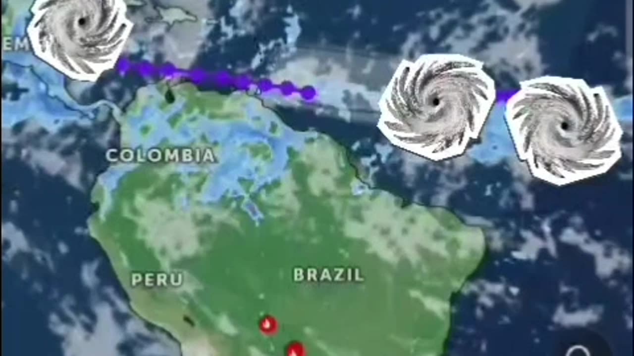
another... TRIPLE THREAT!
Tropical Weather Outlook
NWS National Hurricane Center Miami FL
800 AM EDT Fri Jun 28 2024
For the North Atlantic... #CaribbeanSea and the Gulf of Mexico:
1. Western Caribbean/Southwestern #GulfofMexico (AL94):
A broad area of low pressure over the western Caribbean Sea
associated with a tropical wave continues to produce widespread
shower and thunderstorm activity. Development of this system is not
expected today while it moves west-northwestward at around 15 mph,
and an #Air Force reconnaissance mission planned for today has been
canceled. The disturbance is then expected to move westward over the
Yucatan Peninsula and emerge over the Bay of Campeche late Saturday
or early Sunday, at which point some development will be possible.
Regardless of development, heavy rainfall associated with the
tropical wave will affect portions of Central America and Mexico
through the #weekend
* Formation chance through 48 hours...low...30 percent.
* Formation chance through 7 days...low...30 percent.
2. Central #Tropical #Atlantic (AL95):
A low pressure system located about 1500 miles east-southeast of the
Windward Islands is gradually becoming better defined. Showers and
thunderstorms are also showing signs of organization, and a tropical
depression or #tropicalstorm will likely form later today or on
Saturday. This system is expected to move westward at 15 to 20 mph
and approach the Lesser #Antilles by the end of the weekend.
Interests there should monitor the progress of this system. For
more information, including gale warnings, see High Seas #Forecasts
issued by the National Weather Service.
* Formation chance through 48 hours...high...90 percent.
* Formation chance through 7 days...high...90 percent.
3. Eastern Tropical Atlantic:
A tropical wave centered several hundred miles south-southwest of
the #CaboVerde #Islands is producing disorganized showers and
thunderstorms. Some slow development of this system is possible
next week while it moves generally westward across the central
and western tropical Atlantic at 15 to 20 mph.
* Formation chance through 48 hours...low...near 0 percent.
* Formation chance through 7 days...low...20 percent.
High Seas Forecasts issued by the National Weather Service
Forecaster Cangialosi/Zelinsky
#Hurricane #tornadoes #tornado #tropicalstorm #wind #rain #weather #TiffanysContent #rainfall #ocean #islands #thunderstorms #Beryl #Hurricanes #hurricaneberyl #nhc #zoomearth #earth
www.nhc.noaa.gov
www.zoom.earth.com
-
 13:09
13:09
Forrest Galante
9 hours agoI Went Bowfishing For America's Most Invasive Fish
125K2 -
 11:42
11:42
MattMorseTV
15 hours ago $14.58 earnedShe ADMITTED to ALL OF IT.
24K149 -
 10:58
10:58
MetatronHistory
1 day agoMedieval Dungeons VS Fantasy Dungeons
22.3K3 -
 1:44:46
PandaSub2000
1 day agoUltimate Chicken Horse | ULTRA BEST AT GAMES (HD Edited Replay)
46.8K1 -
 16:25
16:25
GritsGG
15 hours agoWe Were Not Supposed to Regain BUT WE DID! Insane Warzone Victory!
18K -
 1:11:16
omarelattar
5 days agoHow I Went From Depressed w/ $0 To $500 Million Per Year In My 20's (COMFRT CEO Hudson Leogrande)
27.8K2 -
 24:45
24:45
Blabbering Collector
2 days agoUnboxing The 2025 Diagon Alley Advent Calendar By Carat Shop | Harry Potter
42.2K6 -
 LIVE
LIVE
Lofi Girl
3 years agolofi hip hop radio 📚 - beats to relax/study to
396 watching -
 9:48
9:48
MetatronCore
2 days agoHasan Piker ULTIMATE Crash Out!
18.4K6 -
 3:33:47
Nerdrotic
12 hours ago $17.41 earnedNerdrotic At Night 541
192K9