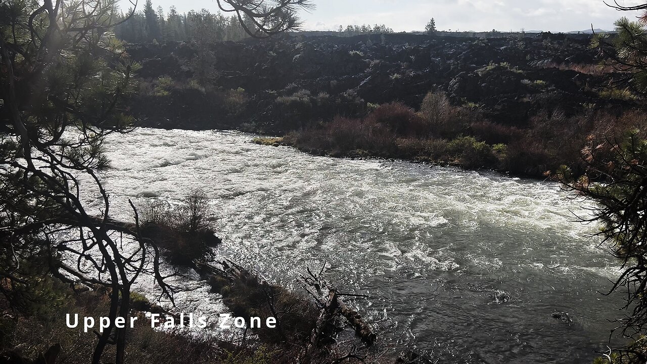
HIKING EXPLORING the Deschutes River Upper Falls Zone IN THE POURING RAIN! | Central Oregon | 4K
Chapters & Timestamps:
0:00 Arriving at the Edge of the EPIC Upper Falls Zone IN THE POURING RAIN!
0:24 Hiking Above the Upper Falls Area, a River Forest Volcanic Lava Rock Wonderland!
0:54 "Silent Perspectives" 4K Montage of 7 Unique Clips of Upper Falls & National Wild & Scenic Upper Deschutes River framed by Deschutes National Forest
In my opinion, there are about 8 Miles of PREMIUM River Shoreline Hiking on Deschutes River Trail along National Wild & Scenic Upper Deschutes River, Deschutes National Forest, Central Oregon.
This is EASILY a TOP 5 River Shoreline Hike in the Great State of Oregon! There are 3 Strategic Approaches to Capture/Tackle this EPIC area:
1) 8 Mile Point-to-Point Hike from Meadow Day Use Area to Sun-Lava Path Trailhead (called East Benham Falls Trailhead on Google Maps), in either Direction, need to arrange transportation at end of Hike!
2) 16 Mile Out & Back Hike from Meadow Day Use Area to Dillon Falls to Benham Falls to Sun-Lava Path Trailhead (called East Benham Falls Trailhead on Google Maps), in either Direction, no transportation logistics required, the Superstar Hiker Method!
3) Break Deschutes River Trail up into 2 separate more leisurely 8-Miles'ish Out & Back Hikes using Dillon Falls as the Midpoint:
a) Meadow Day Use Area Trailhead to Dillon Falls & Back.
b) Sun-Lava Path Trailhead (called East Benham Falls Trailhead on Google Maps) to Dillon Falls & Back.
On April 22, 2022, I Hiked 8 Miles Point-to-Point from Sun-Lava Path Trailhead (called East Benham Falls Trailhead on Google Maps) heading North to Benham Falls, Slough Day Use Area, Dillon Falls, Aspen Day Use Area, Big Eddy, Upper Falls, Lava Island Day Use Area, Lava Island to Meadow Day Use Area. It was a Low of 29F. Here is the FULL HIKE Video Link of that Hike:
On May 6, 2022, I Hiked 8 Miles Point-to-Point from Meadow Day Use Area Trailhead heading South to Lava Island, Lava Island Day Use Area, Upper Falls, Big Eddy, Aspen Day Use Area, Dillon Falls, Slough Day Use Area & Benham Falls to Sun-Lava Path Trailhead (called East Benham Falls Trailhead on Google Maps). It was a Low of 33F. There was a freak Hail Storm that added to the experience:
-
 9:27
9:27
HikingViking
1 month ago(4K UHD) 3 LARGE GROUP CAMPSITES @ Horseshoe Cove Campground! | Baker Lake | Mt. Baker-Snoqualmie NF
451 -
 LIVE
LIVE
CassaiyanGaming
2 hours ago🟢LIVE - VISITING GOOB LAGOON! - Will They Rip Me Off?!? Waterpark Simulator
82 watching -
 LIVE
LIVE
EricJohnPizzaArtist
6 days agoAwesome Sauce PIZZA ART LIVE Ep. #64: Robbie “The Fire” Bernstein
324 watching -
 2:23:58
Nerdrotic
5 hours ago $6.38 earnedDeDunking the Debunkers with Dan Richards | Forbidden Frontier #119
30.6K6 -
 LIVE
LIVE
SlinderPigCamz
2 hours ago $0.21 earnedThe Headliners and other games W/GrinchyGamer101 (Road to 500 Followers)
39 watching -
 LIVE
LIVE
MrOldFart
6 hours agoLIVE - MEGABONK First Playthrough - Mr.OldFart
69 watching -
 LIVE
LIVE
GritsGG
8 hours agoWarzone Win Grinding! Most Wins in WORLD! 3680+!
229 watching -
![[LIVE] STAR WARS: Jedi Academy - Movie Battles 2 | ReaperAF95's Community Event Day 2](https://1a-1791.com/video/fwe2/ce/s8/1/E/Q/f/o/EQfoz.0kob-small-LIVE-STAR-WARS-Jedi-Academy.jpg) LIVE
LIVE
Joke65
4 hours ago[LIVE] STAR WARS: Jedi Academy - Movie Battles 2 | ReaperAF95's Community Event Day 2
12 watching -
 5:41:09
Right Side Broadcasting Network
2 days agoLIVE REPLAY: President Trump to Deliver Remarks at America's Navy 250 in Norfolk, VA - 10/5/25
132K71 -
 LIVE
LIVE
SynsFPS
5 hours ago🔴B07 Beta🔴|🔴 LEVEL CAP INCREASED 🔴|🔴Path to Verify 🔴
60 watching
