⚠️ Severe Storms Tonight: Hail & Tornado Risk in Plains!
⚠️ Stay prepared with your #1 Source for quick Severe Weather Outlooks & Discussions—W.O.F. (Weather On da Fly)! Tonight, severe storms are expected to hit Northern Oklahoma, Southeastern Kansas, and Western Missouri, bringing risks of large hail, damaging winds, and even potential tornadoes. 🌪️ A developing system, coupled with rising dew points and a cold front, has set the stage for intense weather across the Plains this evening through the overnight hours.
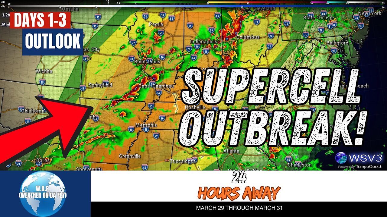
Looking ahead to Sunday, severe weather intensifies across the Ohio, Mid-Mississippi, and Tennessee Valleys, with threats of strong tornadoes, damaging gusts, and large hail. Monday continues the action, with storms spreading across the Northeast, Southeast, and Gulf Coast regions. Stay in the know with trusted updates from NOAA, NHC, and SPC as we track these systems.
Don't miss your daily dose of accurate, up-to-date weather insights! Be sure to #Share, #Like, and #Subscribe to W.O.F. (Weather On da Fly) for all things weather, including tropical updates, hurricane season forecasts, and outlooks for March 2025. 🌩️🌪️☔
CHAPTERS:
00:00 - SPC Outlook
00:08 - Convective Outlook Day 1
02:18 - Convective Outlook Day 2
04:00 - Convective Outlook Day 3
05:36 - Conclusion
-
 1:03:46
TheCrucible
1 hour agoThe Extravaganza! EP: 96 with guest co-host Rob Noerr (02/17/26)
14.9K3 -
 LIVE
LIVE
LFA TV
21 hours agoLIVE & BREAKING NEWS! | TUESDAY 2/17/26
1,082 watching -
 DVR
DVR
vivafrei
3 hours agoLive with Wrongly-Identified Trump "Assassin" Vem Miller - AND MORE!
89.2K15 -
 2:04:23
TetragrammatonPodcast
5 days agoGeorge Saunders
55.5K -
 1:35:16
The Quartering
4 hours agoVERY ODD FACT ABOUT LATEST TRANS MANIAC, THE HERO THAT STOPPED HIM & SUPREME COURT POTENTIAL WIN
108K23 -
 2:31:10
The Confessionals
6 hours agoThe Secret Hill Where Autistic Children Meet Jesus
5.27K2 -
 18:09
18:09
World2Briggs
4 hours agoBlue Cities vs Red States: Why People Move Opposite Their Politics
4.15K2 -
 11:05
11:05
Amy Dangerfield
2 days ago $0.49 earnedAmy Finally RESPONDS to Groypette Allegations
8067 -
 21:13
21:13
Stephen Gardner
3 hours agoPam Bondi’s BIG MISTAKE – Trump MUST Fix This NOW!
33.8K69 -
 11:06
11:06
Clyde Do Something
6 hours ago $2.15 earnedMentally Unstable Man Commits FATAL Shooting in Rhode Island
27.3K5