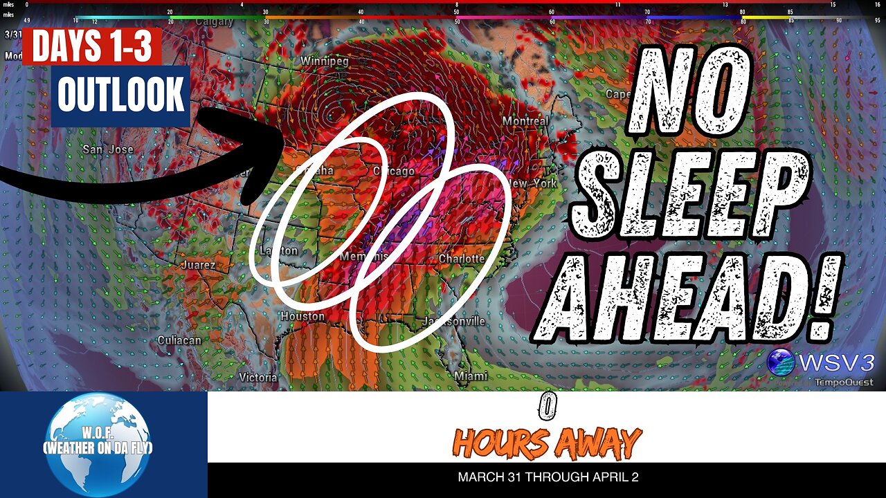
⚠️ Severe Storms & Tornado Risk Today: Southeast Alert! March 31
⚠️ Stay alert, Southeast! Today’s severe storms and potential tornado risk span Southeastern Mississippi, Alabama, the Florida Panhandle, Georgia, South Carolina, and North Carolina. With high winds, heavy rain, and possible tornadoes, conditions demand your attention. This enhanced risk comes as a mid-level trough and surface cyclone fuel storm clusters across the region. Expect strong to severe wind gusts, hail, and isolated tornadoes. Tuesday brings more risks across the Plains, while Wednesday could see a severe weather outbreak across the Midwest and Great Lakes.
Your #1 Source for quick Severe/Tropical Weather Outlooks & Discussions, W.O.F. (Weather On da Fly) keeps you ahead of the storms with the latest updates from NOAA, SPC, and NHC. Stay weather-ready, protect your loved ones, and don’t forget to #Share, #Like, and #Subscribe for more updates this March 2025. 🌩️ #Weather #Tornado #SPC #Outlook #HurricaneSeason #SevereWeather
CHAPTERS:
00:00 - SPC Outlook
00:08 - Convective Outlook Day 1
02:08 - Convective Outlook Day 2
05:01 - Convective Outlook Day 3
06:04 - Final Thoughts and Conclusions
-
 LIVE
LIVE
BonginoReport
2 hours agoThe Internet’s NSFW Reactions To “Bubba” Email - Nightly Scroll w/ Hayley Caronia (Ep.179)
5,452 watching -
 LIVE
LIVE
Barry Cunningham
2 hours agoBREAKING NEWS: PRESIDENT TRUMP SPEAKS TO MCDONALD'S EXECUTIVES AND MORE NEWS!
1,020 watching -
 LIVE
LIVE
The White House
7 hours agoPresident Trump Delivers Remarks at McDonald's Impact Summit
1,362 watching -
 44:39
44:39
Donald Trump Jr.
1 hour agoBuilders vs Bureaucrats, LIVE News Coverage | TRIGGERED Ep.292
25.1K46 -
 LIVE
LIVE
The Jimmy Dore Show
1 hour agoWill Trump’s Attacks on Massie & MTG KILL MAGA? Candace SILENCES Zionist CNN Reporter! w/ Kim Bright
4,996 watching -
 15:55
15:55
T-SPLY
7 hours agoFederal Agents Almost Hit By Fleeing Suspect - Charlotte Clash!
3222 -
 1:12:29
Kim Iversen
2 hours agoTrump Suddenly BEGS for the Epstein Files to Drop | Oxford Union: Israel Is A Bigger Threat Than Iran
79K95 -
 15:55
15:55
Stephen Gardner
1 hour ago🟢YES! Trump's 2 HUGE Orders + Schumer CAUGHT in LEAKED SCANDAL!
5.31K27 -
 LIVE
LIVE
Quite Frankly
6 hours agoStaten Island, Fetterman Rebels, Epstein Rollercoaster | Rich Baris, Jason Bermas 11/17/25
152 watching -
 2:12:53
Redacted News
3 hours agoTRUMP FLIPS ON EPSTEIN NOW WANTS EVERYTHING RELEASED, NEW THOMAS MATTHEW CROOKS REVELATIONS EMERGE
121K98