⚠️ Severe Storms & Tornado Risk: High Plains to Southern Appalachians! June 5-6 Outlook...
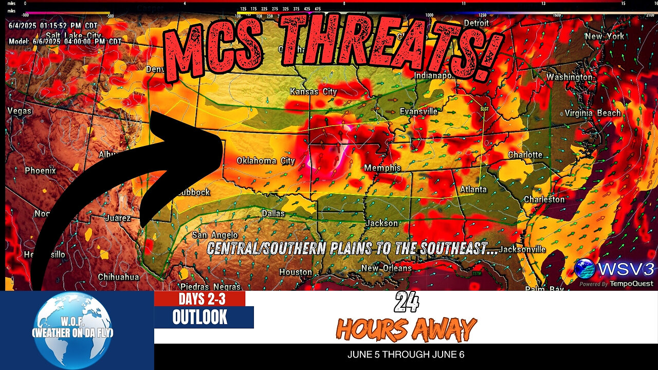
🌩️ Severe storms and tornado risks are ramping up across the High Plains into Oklahoma! Your #1 Source for quick Severe/Tropical Weather Outlooks & Discussions, W.O.F. (Weather On da Fly), brings you the latest SPC updates for June 4, 2025. Stay informed as we break down the potential for large hail, damaging winds, and tornado threats across the southern High Plains, Kansas, and Oklahoma. With unstable conditions and evolving mesoscale systems, the weather could turn volatile, so don’t miss this vital forecast!
From severe thunderstorms in Texas to a weak cold front triggering scattered storms in the Midwest, this video covers everything you need to know. Expect insights into mesoscale convective systems, shear zones, and the risk of hail and tornadoes into Friday. Keep yourself prepared with NOAA and SPC insights during the heart of hurricane season. Stay tuned for updates on weather patterns, temperature changes, and tropical systems.
Don’t miss out—#Share, #Like, and #Subscribe to W.O.F. (Weather On da Fly) for timely forecasts, outlooks, and discussions to keep you weather-ready all year long! 🌪️🔥☀️
#weatherupdatetoday #weathernetwork #weathernews #damagingwinds #oklahomacity
CHAPTERS:
00:00 - Intro
00:08 - Convective Outlook Day 2
02:30 - Convective Outlook Day 3
-
 LIVE
LIVE
Quite Frankly
4 hours agoVatican Rumors, Demon Hunting, Spooky Extras | Leo Zagami 10/22/25
389 watching -
 LIVE
LIVE
The Mike Schwartz Show
1 hour agoTHE MIKE SCHWARTZ SHOW Evening Edition 10-22-2025
2,949 watching -
 1:27:14
Kim Iversen
3 hours agoCBS Boss Colluded With Israel to SPY on Americans | Trump Keeps Bombing Fisheman
34.5K72 -
 1:02:18
TheCrucible
2 hours agoThe Extravaganza! EP: 58 with Guest Co-Host: Rob Noerr (10/22/25)
54.5K6 -
 LIVE
LIVE
StoneMountain64
6 hours agoBattlefield 6 New Season Details NO 'BR' MENTIONED YET
50 watching -
 17:47
17:47
Bearing
10 hours agoThe Most ANNOYING Podcast EVER 💥 ROSIE O’DONNELL & ABBIE CHATFIELD Whinge About EVERYTHING 🤡
5.24K22 -
 LIVE
LIVE
GritsGG
4 hours agoRanked Top 70! Most Wins in WORLD! 3744+!
54 watching -
 1:52
1:52
NAG Daily
4 days agoTHE BIGGEST CREATOR COLLAB SHOW ON RUMBLE W/GreenMan Reports
4.81K2 -
 LIVE
LIVE
Tundra Tactical
2 hours ago $5.08 earnedProfessional Gun Nerd Plays Battlefield 6
141 watching -
 55:25
55:25
Dad Saves America
6 hours ago $1.26 earnedWill China Overtake America? Balaji Srinivasan VS Steve Bannon on the Trade War
11.9K4