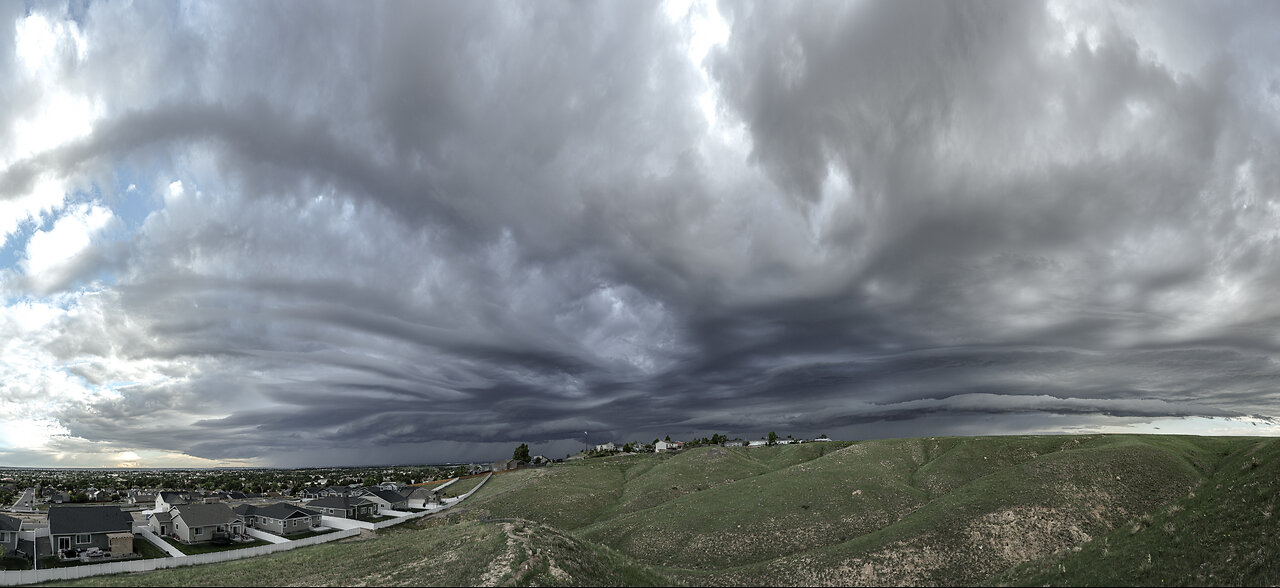
Arcus Cloud (25 Jun 25)
3 months ago
45
The motion and structure of the clouds is hypnotic.
An arcus cloud is a low, horizontal cloud formation associated with the leading edge of a thunderstorm's outflow, often appearing as a wedge-shaped or shelf-like cloud. It forms when cold air from the thunderstorm's downdraft pushes under warmer, moist air, causing the warm air to rise and condense into a cloud. Arcus clouds are typically seen with cumulonimbus clouds and can indicate strong winds or severe weather, such as gust fronts or squall lines. They are most common in warm, humid conditions and can stretch for miles across the sky. Visually, they often look dramatic, with a dark, ominous appearance due to the dense, turbulent air.
Loading 1 comment...
-
 6:07
6:07
Weather Sky & Clouds
1 month agoCritics Choice - Part 2
111 -
 LIVE
LIVE
SpartakusLIVE
1 hour ago#1 Solo Spartan Sunday || TOXIC Comms, TACTICAL Wins, ENDLESS Content
279 watching -

vivafrei
8 hours agoEp. 284: Ostrich Crisis Continues! Kirk Updates! Fed-Surrection Confirmed? Comey Indicted! AND MORE!
42.7K48 -
 LIVE
LIVE
IsaiahLCarter
8 hours agoAntifa Gets WRECKED. || APOSTATE RADIO 030 (Guests: Joel W. Berry, Josie the Redheaded Libertarian)
413 watching -
 2:43:09
putther
3 hours ago $2.99 earned⭐ GTA ONLINE BOUNTIES THEN GTA IV ❗
23.1K5 -
 LIVE
LIVE
EricJohnPizzaArtist
6 days agoAwesome Sauce PIZZA ART LIVE Ep. #63: Charlie Sheen
99 watching -
 LIVE
LIVE
GritsGG
5 hours agoQuad Win Streaks!🫡 Most Wins in WORLD! 3600+
182 watching -
 1:20:13
Sports Wars
11 hours agoCollege Football UPSETS, MLB Playoff Drama, NFL Week 4
82.7K13 -
 LIVE
LIVE
Spartan
2 hours agoOMiT Spartan | Watching TSM 5K with chat + Black Myth Wukong + Ranked on Infinite Maybe
52 watching -
![🔴[LIVE] Sept RCP #27💜 [English Chat] 😍DGG-a-Thon! Forever Skies maybe other game later ....💜](https://1a-1791.com/video/fwe2/ee/s8/1/0/t/e/m/0temz.0kob-small-LIVE-Sept-RCP-27-English-Ch.jpg) LIVE
LIVE
Deaf Gamer Girl
2 hours ago🔴[LIVE] Sept RCP #27💜 [English Chat] 😍DGG-a-Thon! Forever Skies maybe other game later ....💜
48 watching