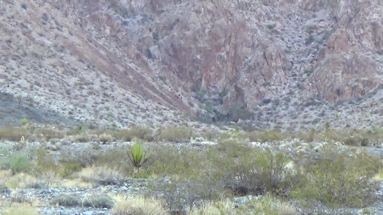
Bottom Contacts of the Plutons 10 Miles Down
35.680935, -114.927266
Looking for the contact between the Keyhole leucogranite pluton intruding the Nelson quartz monzonite pluton where they met 10 miles below somewhere 15 million years ago before tilting 130 degrees to the east into the Colorado extensional corridor graben. The Nelson Pluton was found to be a more mafic Diorite here due to fractionalization and sinking of the mafic crystals to the bottom of the magma chamber. Fractionalization on cooling is explained by Bowens Reaction Series and iron heavies sink.
I went up the wrong canyon from what I intended but all's well that ends well. Next time I'll have an easier hike up the next canyon to the south (35.678294, -114.926684).
Here is great overview of Southern Nevada geology with some info on the Keyhole and Nelson Plutons (search Keyhole):
Mineral Resource Assessment of Selected Areas in Clark and Nye Counties, Nevada
https://pubs.usgs.gov/sir/2006/5197/#:~:text=Mineral%20Resource%20Assessment%20of%20Selected%20Areas%20in%20Clark%20and%20Nye%20Counties
I have not found a surface geologic map of this area to go by so I'm doing my best by interpolation of nearby map's plutons and dates:
Ireteba Peaks map to the south:
https://pubs.nbmg.unr.edu/Geol-Ireteba-Peaks-quad-p/of2012-09.htm
Black Canyon map to the north:
https://pubs.usgs.gov/of/2013/1267/a/
Beatles on YouTube:
https://www.youtube.com/watch?v=GKdl-GCsNJ0
-
 3:03
3:03
Rocks of Eldorado NV
1 month agoGrapes of Wrath
131 -
 1:29:23
Glenn Greenwald
7 hours agoMarco Rubio, Europe Thwart Ukraine Peace Deal; NSA Illegally Leaks Steve Witkoff's Diplomatic Calls; Bari Weiss's Comically Out of Touch Plan for CBS | SYSTEM UPDATE #550
136K76 -
 51:15
51:15
State of the Second Podcast
8 hours agoCan You Trust Paid Gun Reviews? (ft. Tactical Advisor)
3.27K1 -
 8:56
8:56
MetatronGaming
6 hours agoSuper Nintendo NA vs PAL
18.3K8 -
 20:02
20:02
Scammer Payback
8 hours agoHijacking a Scammer Group's Live Video Calls
5.87K1 -
 3:18:30
Nikko Ortiz
6 hours agoArc Raiders 1st Gameplay... | Rumble LIVE
34K2 -
 2:17:05
Blabs Life
8 hours agoPART 3: Peter Jackson's King Kong: The Official Game of the Movie | Noob Plays
21.6K2 -
 18:07
18:07
MetatronCore
6 hours agoAmala Ekpunobi is BASED
21.5K7 -
 1:01:48
BonginoReport
7 hours agoWaddle & Gobble Receive Presidential Pardons! - Nightly Scroll w/ Hayley Caronia (Ep.185)
124K32 -
 53:41
53:41
Katie Miller Pod
5 hours agoMike & Kelly Johnson on Marriage, Family, & Demands of the Job | The Katie Miller Podcast Ep. 16
43.1K15