Premium Only Content

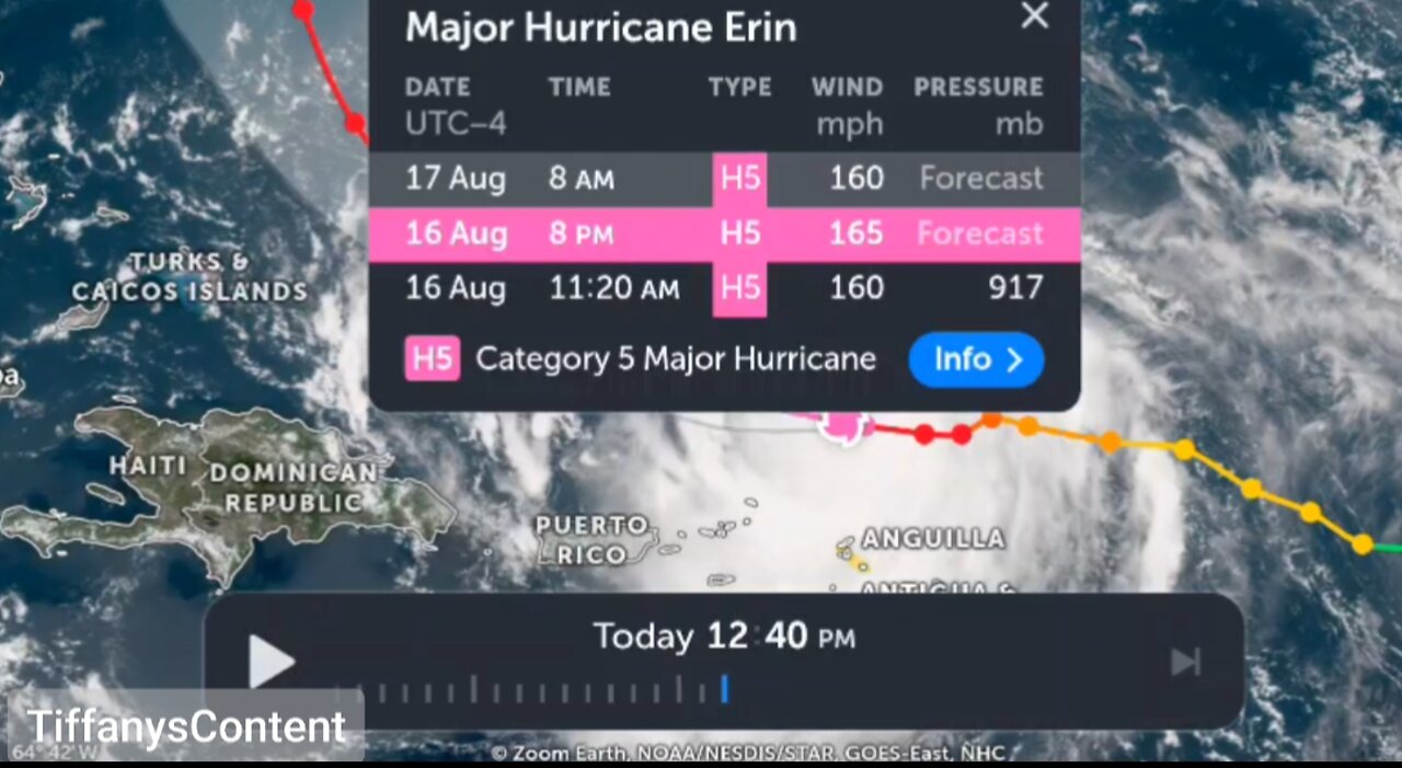
CATASTROPHIC CATEGORY 5 HURRICANE...
AIR FORCE RESERVE HURRICANE HUNTERS FIND ERIN IS NOW A
CATASTROPHIC CATEGORY 5 HURRICANE...
Reports from an Air Force Reserve Hurricane Hunter aircraft
indicate that Erin has become a Category 5 hurricane on the
Saffir-Simpson Hurricane Wind Scale with maximum sustained winds
near 160 mph (255 km/h). The minimum pressure has fallen to near
917 mb (27.08 inches). The next intermediate advisory will be issued
at 200 PM AST (1800 UTC).
SUMMARY OF 1120 AM AST...1520 UTC...INFORMATION
----------------------------------------------
LOCATION...19.7N 62.8W
ABOUT 105 MI...170 KM N OF ANGUILLA
MAXIMUM SUSTAINED WINDS...160 MPH...255 KM/H
PRESENT MOVEMENT...W OR 280 DEGREES AT 17 MPH...28 KM/H
MINIMUM CENTRAL PRESSURE...917 MB...27.08 INCHES
$$
Forecaster Beven/Kelly
Heavy rainfall at times through Sunday across the northern Leeward Islands, the Virgin Islands, and Puerto Rico may lead to locally considerable flash and urban flooding, along with landslides or mudslides.
Gusts to tropical storm force in Erin's outer rainbands are likely in portions of the northern Leeward Islands through tonight and over portions of the Virgin Islands and Puerto Rico later today (16 August) through Sunday. Tropical-storm force wind gusts are possible in the Turks and Caicos Islands and Southeast Bahamas
Erin is expected to produce life-threatening surf and rip currents along the beaches of the Bahamas, much of the east coast of the U.S., and Atlantic Canada next week.
Interests in Bermuda should continue to monitor the progress of Erin since there is a risk of strong winds, heavy rainfall, and high surf by the middle part of next week.
Erin has continued to rapidly strengthen during the past 6 hours and is now a category 4 hurricane. Reports from Air Force Reserve Hurricane Hunter aircraft indicate that the central pressure has fallen to 925 mb inside a 6 nautical miles wide eye, and flight-level winds in the northern eyewall support surface winds in the 130–135 knots range. The initial intensity is increased to 155 mph (135 knots), a 70-knots increase since 24 hours ago. The aircraft, along with land-based radar data from Sint Maarten, report that an outer eyewall is starting to form. However, this has yet become apparent in the aircraft wind data.
The hurricane has been moving a bit to the left of the previous forecast track with the initial motion of 280/15. The track guidance suggests that Erin will turn back to the west-northwest with a decrease in forward speed during the next 6–12 hours on the south side of a subtropical ridge.
-
 12:03
12:03
Actual Justice Warrior
1 day agoLow IQ Criminal SNITCHES On HIMSELF
9.55K13 -
 57:01
57:01
Dialogue works
2 days ago $0.85 earnedMatthew Hoh: Is Netanyahu Pushing the US Into War With Iran?
8.13K9 -
 5:50:42
SLS - Street League Skateboarding
23 days agoSLS Sydney Men's & Women's Knockout Rounds | WATCH LIVE FEBRUARY 14, 2026 🛹
282K10 -
 2:07:35
FreshandFit
14 hours agoWhy Are Women Single This Valentines Day? w/ Jack Morgan RLP
61.2K51 -
 6:01:58
Akademiks
7 hours agoTI and 50 Cent Both Call each other RATS. Tony Yayo explains Ja Rule isnt like DAT! Brorilla up200k?
49.2K3 -
 11:40
11:40
Clyde Do Something
19 hours ago $1.59 earnedWhy Canada’s Deal With China Was the FIRST STEP
23.6K22 -
 2:05:15
TimcastIRL
10 hours agoDon Lemon Pleads NOT GUILTY After STORMING Church, Feds SEIZE His Phone
291K109 -
 2:07:02
Sam Tripoli
1 day ago $25.64 earnedBS Live!: Bondi vs. Massie on Epstein + Les Wexner's Demon + Really Bad Bunny
93.9K28 -
 4:13:00
SynthTrax & DJ Cheezus Livestreams
2 days agoFriday Night Synthwave 80s 90s Electronica and more DJ MIX Livestream - REQUESTS AND VISUALS
47.3K1 -
 1:03:17
Doing Time with George Santos
15 hours ago $7.55 earnedRAGE BAITING MATAN EVEN... (fun fact: this thumbnail ENRAGES him)
47.2K3