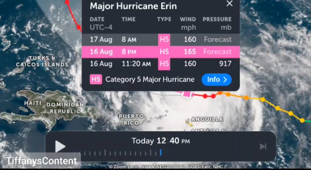
CATASTROPHIC CATEGORY 5 HURRICANE...
AIR FORCE RESERVE HURRICANE HUNTERS FIND ERIN IS NOW A
CATASTROPHIC CATEGORY 5 HURRICANE...
Reports from an Air Force Reserve Hurricane Hunter aircraft
indicate that Erin has become a Category 5 hurricane on the
Saffir-Simpson Hurricane Wind Scale with maximum sustained winds
near 160 mph (255 km/h). The minimum pressure has fallen to near
917 mb (27.08 inches). The next intermediate advisory will be issued
at 200 PM AST (1800 UTC).
SUMMARY OF 1120 AM AST...1520 UTC...INFORMATION
----------------------------------------------
LOCATION...19.7N 62.8W
ABOUT 105 MI...170 KM N OF ANGUILLA
MAXIMUM SUSTAINED WINDS...160 MPH...255 KM/H
PRESENT MOVEMENT...W OR 280 DEGREES AT 17 MPH...28 KM/H
MINIMUM CENTRAL PRESSURE...917 MB...27.08 INCHES
$$
Forecaster Beven/Kelly
Heavy rainfall at times through Sunday across the northern Leeward Islands, the Virgin Islands, and Puerto Rico may lead to locally considerable flash and urban flooding, along with landslides or mudslides.
Gusts to tropical storm force in Erin's outer rainbands are likely in portions of the northern Leeward Islands through tonight and over portions of the Virgin Islands and Puerto Rico later today (16 August) through Sunday. Tropical-storm force wind gusts are possible in the Turks and Caicos Islands and Southeast Bahamas
Erin is expected to produce life-threatening surf and rip currents along the beaches of the Bahamas, much of the east coast of the U.S., and Atlantic Canada next week.
Interests in Bermuda should continue to monitor the progress of Erin since there is a risk of strong winds, heavy rainfall, and high surf by the middle part of next week.
Erin has continued to rapidly strengthen during the past 6 hours and is now a category 4 hurricane. Reports from Air Force Reserve Hurricane Hunter aircraft indicate that the central pressure has fallen to 925 mb inside a 6 nautical miles wide eye, and flight-level winds in the northern eyewall support surface winds in the 130–135 knots range. The initial intensity is increased to 155 mph (135 knots), a 70-knots increase since 24 hours ago. The aircraft, along with land-based radar data from Sint Maarten, report that an outer eyewall is starting to form. However, this has yet become apparent in the aircraft wind data.
The hurricane has been moving a bit to the left of the previous forecast track with the initial motion of 280/15. The track guidance suggests that Erin will turn back to the west-northwest with a decrease in forward speed during the next 6–12 hours on the south side of a subtropical ridge.
-
 LIVE
LIVE
VINCE
2 hours agoPelosi Is Passing The Torch - Who's Next? | Episode 164 - 11/07/25 VINCE
27,066 watching -
 1:42:21
Graham Allen
2 hours agoPARTY AT WAR!! We Need to Get It Together Or We Lose 2028…
83.8K51 -
 1:06:37
Chad Prather
14 hours agoApplying The POWER Of Christ To Your Life!
58.8K23 -
 LIVE
LIVE
LFA TV
13 hours agoLIVE & BREAKING NEWS! | FRIDAY 11/7/25
3,123 watching -
 1:05:59
Crypto Power Hour
14 hours ago $0.14 earnedTop 10 Cryptocurrency Staking Platforms
48.1K10 -
 35:53
35:53
Mike Rowe
1 day agoBreaking Down Bill Gates' 3 Tough Truths About Climate | Alex Epstein #457 | The Way I Heard It
69.5K51 -
 23:22
23:22
Stephen Gardner
1 day ago🚨BREAKING: Mamdani Won and What Trump EXPOSES About It is SHOCKING!!
49.6K140 -
 1:16:41
Steve-O's Wild Ride! Podcast
22 hours ago $0.06 earnedAdam Ray Absolutely Kills Steve-O | Wild Ride #273
39K5 -
 37:22
37:22
efenigson
1 day agoWhat COVID Taught Me About Money & Control - Efrat Fenigson | Ep. 104
30.9K4 -
 1:20:56
Dialogue works
2 days ago $0.58 earnedCol. Larry Wilkerson: No Way Out for Israel - Iran & Russia — NATO’s Worst Fear
57.1K14