MAJOR HURRICANE ERIN EXPECTED TO INTENSIFY AGAIN WHILE GROWING IN SIZE...
EXPECTED TO INTENSIFY AGAIN WHILE GROWING IN SIZE...
#Hurricane #majorhurricane #storm #turksandcaicos #Bahamas #Puertorico #weather #flood
SUMMARY OF 500 PM AST...2100 UTC...INFORMATION
----------------------------------------------
LOCATION...21.7N 68.5W
ABOUT 275 MI...445 KM NW OF SAN JUAN PUERTO RICO
ABOUT 165 MI...270 KM E OF GRAND TURK ISLAND
MAXIMUM SUSTAINED WINDS...125 MPH...205 KM/H
PRESENT MOVEMENT...WNW OR 295 DEGREES AT 13 MPH...20 KM/H
MINIMUM CENTRAL PRESSURE...946 MB...27.94 INCHES
WATCHES AND WARNINGS
--------------------
CHANGES WITH THIS ADVISORY:
None.
SUMMARY OF WATCHES AND WARNINGS IN EFFECT:
A Tropical Storm Warning is in effect for...
* Turks and Caicos Islands
* Southeast Bahamas
A Tropical Storm Warning means that tropical storm conditions are
expected somewhere within the warning area, in this case within 24
hours.
Interests elsewhere in the central Bahamas, the North Carolina
Outer Banks, and Bermuda should monitor the progress of Erin.
For storm information specific to your area, please monitor
products issued by your national meteorological service.
nhc
Bands of heavy rainfall will continue across portions of Puerto Rico and the Virgin Islands through tonight, but are expected to diminish by Monday. Locally considerable flash and urban flooding, along with landslides or mudslides, are possible.
Tropical storm conditions are expected in the Turks and Caicos Islands and in the southeast Bahamas tonight and Monday.
Erin is expected to produce life-threatening surf and rip currents along the beaches of the Bahamas, much of the east coast of the U.S., Bermuda, and Atlantic Canada during the next several days.
Interests along the Outer Banks of North Carolina and Bermuda should monitor the progress of Erin as there is a risk of strong winds associated with the outer rainbands during the middle part of the week.
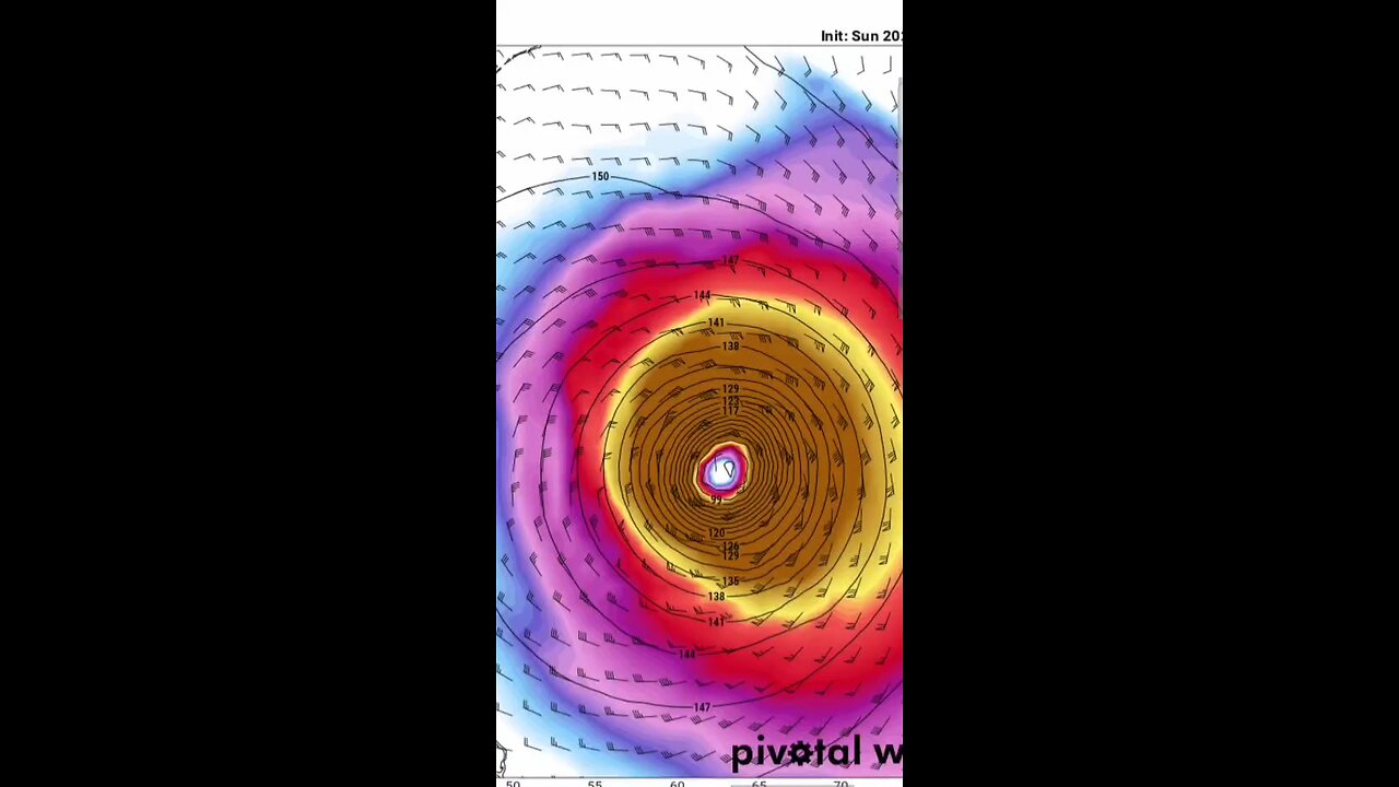
Erin continues to have a well-organized cloud pattern with numerous convective banding features and strong upper-level outflow. Satellite data indicate numerous lightning flashes in these cloud bands. The intensity estimate is held at 125 mph (110 knots) for this advisory, which is somewhat below the Dvorak values, but close to the estimate based on the most recent aerial reconnaissance mission. Another Air Force Hurricane Hunter plane is scheduled to investigate Erin in a few hours to provide an update on the strength of the hurricane.
zoom earth
other sources
tropical tidbits
pivotal weather
goes star
-
 23:12
23:12
Jasmin Laine
20 hours agoPoilievre LOSES PATIENCE—His “Who CARES?” Moment SHOCKED Everyone
100K36 -
 LIVE
LIVE
Sgt Wilky Plays
4 hours agoFirst Run of Black Ops 7 after the Beta | Multiplayer
257 watching -
 6:49
6:49
The Car Guy Online
13 hours ago $8.53 earned2025–2026 Duramax FAILURES Begin! GM’s NEW Engine Nightmare? Silverado, Sierra, Yukon...
18.9K21 -
 LIVE
LIVE
Boxin
4 hours agoKingdom Hearts! This is Halloween Town!
161 watching -
 8:34
8:34
Millionaire Mentor
20 hours agoTrump FIRES BACK After Mamdani’s SHOCKING Threat To New York City
31.2K40 -
 3:32:56
EXPBLESS
4 hours agoThis Might Be The Last Game I Ever Play | 🔴ARC RAIDERS SOLO RAIDS 🔴
12.3K1 -

IamNibz
2 days ago $0.71 earnedPansy Umbrellas And Buff Emo Horse- WHERE WINDS MEET! (Ft. Diony)
9.81K1 -
 53:56
53:56
ZeeeMedia
22 hours agoSilicon Valley, Transhumanists & the Book of Revelation ft. Jay Dyer | Daily Pulse Ep 144
24.6K22 -
 1:02:02
A Cigar Hustlers Podcast Every Day
1 day agoEpisode 4 Hustler Every Day Target 10/4, No More Pennies and Gronk Is The Man
20K1 -
 3:07
3:07
GreenMan Studio
1 day agoHOW TO NOT SELL OUT IN 2025 W/Greeman Reports
16.8K6