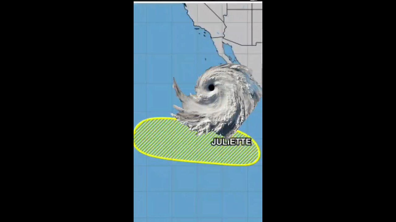
TROPICAL STORM #JULIETTE A LITTLE STRONGER... TIP OF BAJA CALIFORNIA
TROPICAL STORM #JULIETTE A LITTLE STRONGER... TIP OF BAJA CALIFORNIA
#tropicalstorm #tropicalstormjuliette
SUMMARY OF 800 AM MST...1500 UTC...INFORMATION
LOCATION...17.1N 113.1W
ABOUT 180 MI...290 KM SW OF SOCORRO ISLAND
ABOUT 450 MI...725 KM SSW OF THE SOUTHERN TIP OF #BAJACALIFORNIA
MAXIMUM SUSTAINED WINDS...45 MPH...75 KM/H
PRESENT MOVEMENT...WNW OR 290 DEGREES AT 13 MPH...20 KM/H
MINIMUM CENTRAL PRESSURE...1003 MB...29.62 INCHES
WATCHES AND WARNINGS
--------------------
There are no coastal watches or warnings in effect
DISCUSSION AND OUTLOOK
----------------------
At 800 AM MST (1500 UTC), the center of Tropical Storm Juliette was located near latitude 17.1 North, longitude 113.1 West. Juliette is moving toward the west-northwest near 13 mph (20 km/h), and this general motion is expected to continue through early Tuesday. A turn toward the northwest is forecast later on Tuesday, followed by a slower motion toward the north-northwest by early Thursday. Maximum sustained winds are near 45 mph (75 km/h) with higher gusts. Additional strengthening is forecast during the next day or two, with weakening beginning on Wednesday. Tropical-storm-force winds extend outward up to 60 miles (95 km) from the center. A wind gust to 44 mph (71 km/h) was recently reported by an automated Mexican navy station on Clarion Island.
The estimated minimum central pressure is 1003 mb (29.62 inches).
#Hurricane
HAZARDS AFFECTING LAND
----------------------
None
-
 1:04:49
Timcast
2 hours agoTrump Goes NUCLEAR At Rally, Demands Ilhan Omar Be DEPORTED
134K28 -

Silver Dragons
58 minutes agoBullion Dealer Reacting to $60 Silver Price (Insane)
-
 1:51:30
Steven Crowder
5 hours agoTrump Unloads on Europe...and Who Can Really Be American?
336K242 -
 1:01:15
The Rubin Report
3 hours agoIlhan Omar Just Got Scared After Trump’s Brutal Threat to Her
32.4K60 -
 LIVE
LIVE
LFA TV
15 hours agoLIVE & BREAKING NEWS! | WEDNESDAY 12/10/25
2,559 watching -
 1:00:55
VINCE
5 hours agoIt Was a Bad Night For the Liberal Lunatics | Episode 185 - 12/10/25 VINCE
222K135 -
 2:10:05
Benny Johnson
4 hours agoHow The America First Movement Can Win The Midterms | Trump Enters Campaign Mode at MASSIVE Rally...
72.1K51 -
 47:42
47:42
MYLUNCHBREAK CHANNEL PAGE
22 hours agoExposing the Old World Destruction
19.8K6 -
 1:44:46
The Mel K Show
3 hours agoMORNINGS WITH MEL K - Is it time for the Insurrection Act? The people demand Accountability and consequences 12-10-25
18.1K2 -
 37:24
37:24
Tudor Dixon
4 hours agoGut Health and Fertility with Dr. Ann Shippy | The Tudor Dixon Podcast
9.29K