🇮🇱 West Bank Update: Israeli E1 Settlement Plan
🚨🇮🇱 West Bank Update: Israeli E1 Settlement Plan Exposed!
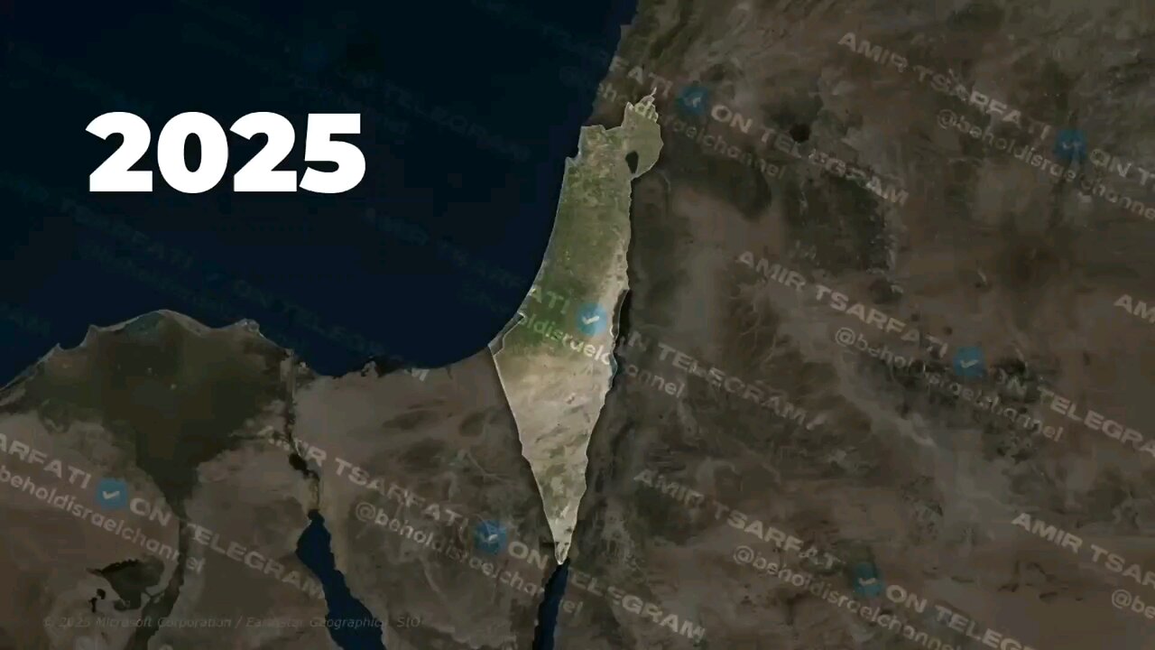
Our new maps, overlaying historical and current realities, reveal how Israel's latest E1 advancement, announced by Finance Minister Bezalel Smotrich, would permanently divide the occupied West Bank, isolating East Jerusalem and making a viable Palestinian state impossible.
🗺 Key Divisions:
- 1948 Snapshot: West Bank under Jordanian control until Israel's conquest in the 1967 Six-Day War, which also captured Sinai (later returned to Egypt for peace), shown in unified blue territory.
- 2025 Areas: Red (Area A, 18%, Palestinian Authority administered); Purple (Area B, 22%, PA admin with shared Israeli security); Teal (Area C, 60%, fully Israeli-controlled).
- E1 Corridor: Green-striped zone linking Jerusalem to Ma'ale Adumim, severing northern cities like Ramallah from southern ones like Bethlehem and Hebron.
- Strategic Impact: Splits the West Bank in two, blocks Palestinian territorial contiguity, and "buries" the two-state solution, per Smotrich's own words.
📱 Watch the full update: https://www.youtube.com/live/mAFOF8QufVI?si=Ofj7QWTvJARwt_Mg
✡️ Share the facts!
-
 34:31
34:31
Real Conservative News TT
1 day agoNEWS REPORT TRINIDAD & TOBAGO October 17th 2025 Headline News
8 -
 9:22
9:22
Colion Noir
6 hours agoArmed Woman Drags Gunman Out of Store Before Firing Two Shots
64.3K34 -
 LIVE
LIVE
Jeff Ahern
2 hours agoThe Saturday Show with Jeff Ahern
179 watching -
 44:34
44:34
Chris Harden
2 days agoWhat Happened to Rock Island, Illinois?
3.59K2 -
 30:56
30:56
Advanced Level Diagnostics
6 days ago2004 Chevy Silverado - Won't Shut Off!
3.89K -
 7:05
7:05
Spooky Grandpa's Scary Stories
7 months agoThose Who Linger - Halloween, Ghost Stories, Horror, Haunted, Cemetery, Folklore
3.09K15 -
 2:23
2:23
Memology 101
1 day ago $0.63 earnedAOC spits completely made-up BULLSH*T during UNHINGED anti-Republican rant
3.5K23 -
 1:55
1:55
NAG Daily
20 hours agoHEADLINES FOR THE JILTED MASSES W/GreenMan Reports
1.76K1 -
 LIVE
LIVE
GrimmHollywood
4 hours ago🔴LIVE • GRIMM HOLLYWOOD • ARC RAIDERS • DAY 2 •
139 watching -
 3:02:36
CassaiyanGaming
4 hours ago🟢LIVE - BATTLEFIELD 6 - MEDIC SHIFT - Doing My Duty
22.8K