(4K UHD) HIKING HIGHLIGHTS - Exploring the Top of Black Crater Summit! | Three Sisters Wilderness
*This Video is 4K UHD - it is made to watch on a Big Screen Smart TV!*
Chapters & Timestamps:
0:00 Exploring the Volcanic Summit Zone
1:51 Descending Black Crater Trail
3:53 Anti-Mosquito Contrarian Hiking Play Strategy
Here is the FULL HIKE VIDEO of Black Crater Trail from Trailhead to Volcanic Summit: https://youtu.be/4orh9kijlu4
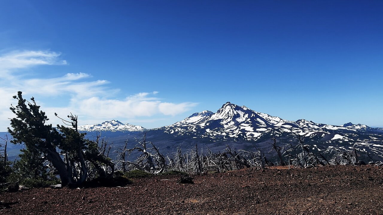
*Black Crater Trail* is a Day-Hike in Central Oregon, Three Sisters Wilderness, accessible via McKenzie Highway 242, and is 7.2 - 8 Miles, 2300+ FT Elevation Gain, Out & Back. Please note the Trailhead Sign says 4 Miles to Summit which would be 8 Miles Roundtrip, so it's somewhere between 7.2 Miles (AllTrails) and 8 Miles (Local Signage), and in all reality there isn't much of a difference between 7.2 Miles and 8 Miles to a Wilderness Adventurer.
I did this on July 3, 2025, a weekday, arrived around 6:45 AM, was the only Car in the Parking Lot, and had a totally private Hiking experience all the way up to the Summit as the only person on the Trail. I would recommend following this model timing wise because the Sunlight horizontally beaming on the flowers as you ascend the burnout was well timed and felt like a special vibrant lightshow display. On the way back down the area looked quite different in full day-time sunshine splendor, so it gave the area two very distinct feels. Also, you want to ascend early when the temps are low for proper temperature management since it's primarily up a burnout and exposed virtually the entire Hike! *Also, and perhaps most importantly, this is a Anti-Mosquito Contrarian Hiking Play* - typically June/July are HORRENDOUS for Mosquitoes in The Cascades of Oregon/Washington, BUT NOT IN BURNOUT AREAS - it's a HIKING HACK to focus on Burnout Zones like Mount Jefferson Wilderness, Mount Washington Wilderness, this Black Crater Trail, etc, which will either have very limited mosquitoes or in many cases absolutely NO MOSQUITOES! I did this entire Hike and didn't see a single Mosquito or get a single bite!
When you get to about 6500 FT, you get to what feels like a good backpacking area with several flat areas a bit off Trail suitable for a tent. Also, the topographical profile changes, it goes from the Vast Burnout Zone to classic Three Sisters Wilderness mangled hardy Trees of Pines, Spruces & Mountain Hemlocks aka the Alpine Mix 3. From about 6500 FT to the Summit feels like it could be in the Tam McArthur Rim to Broken Hand Area. When I got to about 6900 FT the Snow was super thick, several feet deep, and it was not possible to continue on the Trail. Instead I did my own Route-finding using GPS to walk around the vast Snow Banks and crossed/ascended at some safer points. I can say with confidence that T-Mobile 5G works for the entirety of the Trail, can't speak to other Carriers. I found it to be a fun process that added some excitement to it and it never felt sketch, so it overall enhanced my enjoyment. That said, July 3 is probably a little aggressive to do this, I might recommend around July 7th - July 21th range to increase the likelihood that the Trail is unobstructed by Snow, and of course Snow Levels fluctuate year to year.
*Nearby Hikes.....*
Pacific Crest Trail McKenzie Pass to Little Belknap & Belknap Craters: https://youtu.be/OCQZDNgTkPs
Hiking Three Sisters Wilderness Jewels - No Name Lake, Broken Top & Bend Glacier: https://youtu.be/yCzxpvLtrHk
Tam McArthur Rim Trail to Broken Hand to Bend Glacier, Broken Top & No Name Lake: https://youtu.be/wYN0v2NTsg8
-
 10:54
10:54
HikingViking
1 month ago(4K UHD) HIKING HIGHLIGHTS - Elk Wallow Falls @ Sweet Creek Trail! | Siuslaw NF | Oregon Coast Range
841 -
 2:21
2:21
NAG Daily
11 hours agoPOLITICAL FAMILY GAMESHOW w/ GreenMan Reports
16 -
 0:49
0:49
OfficialJadenWilliams
15 hours agoGTA 6 is downloading but you hear trumpets outside
601 -
 LIVE
LIVE
The Bubba Army
20 hours agoEpstein Trump PICS? | Bubba the Love Sponge® Show | 10/08/2025
4,964 watching -
 1:02:11
DeVory Darkins
14 hours ago $39.22 earnedDemocrats suffers ANNIHILATION during heated hearing with Bondi as Jack Smith bombshell drops
165K113 -
 57:17
57:17
Dialogue works
2 days ago $2.19 earnedAmb. Chas Freeman: Israel on the EDGE: Is TOTAL DEFEAT IMMINENT?!
31.9K12 -
 14:06
14:06
Actual Justice Warrior
1 day agoSomali Medicaid SCAMMER Says Theft Is HIS CULTURE
16.2K22 -
 10:27
10:27
itsSeanDaniel
2 days agoCBS Host INSTANTLY REGRETS Interrupting MAGA SuperStar
19.2K8 -
 1:25:01
Coin Stories with Natalie Brunell
1 day agoThe Coming Currency War: Gold, Dollar, and Bitcoin with Matthew Pines
16K2 -
 LIVE
LIVE
GritsGG
20 hours ago36 Hour Marathon Stream! Most Wins in WORLD! 3704+!
1,421 watching
