Rome from Above – Aerial Journey Across the Eternal City with Google Earth
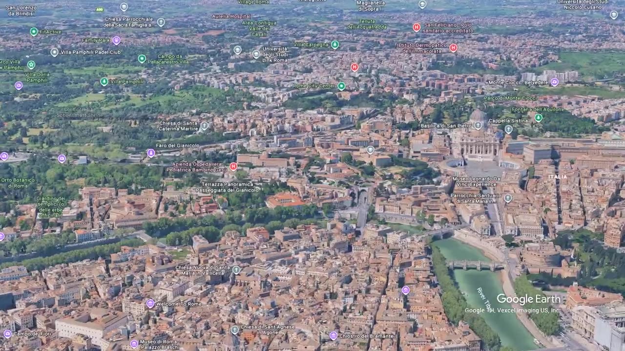
Exploring Rome from above using Google Earth reveals a city shaped by empires, faith, and unmatched layers of history. This aerial journey sweeps over the Colosseum, the Roman Forum, the Pantheon, and the long spine of the Via dei Fori Imperiali before drifting across Piazza Navona and the Baroque heart of the old city.
The flight continues above Vatican City, Saint Peter’s Basilica, Castel Sant’Angelo, and the sweeping curve of the Tiber. From the ancient walls of the Palatine to the perfect geometry of the Spanish Steps and the Trevi Fountain, Rome’s landmarks stand out clearly from the air.
Seen from above, the city’s dense streets, archaeological zones, Renaissance palaces, and grand piazzas tell a continuous story of 2,000 years of urban life.
-
 1:18:05
vivafrei
2 hours agoMTG Goes on CNN & Goes OFF on Trump! Kyle Serraqphin's Motion to Dismiss Patel GF's Lawsuit & MORE!
22.2K43 -
 25:24
25:24
Jasmin Laine
2 hours agoPierre Poilievre OBLITERATES Mark Carney— Reads the Liberals’ OWN Words Back to Them
3.12K6 -
 19:09
19:09
Nicholas Bowling
53 minutes agoStreet Preaching at LGBTQ Event ESCALATED Quick!
-
 LIVE
LIVE
LFA TV
18 hours agoLIVE & BREAKING NEWS! | WEDNESDAY 12/10/25
1,311 watching -
 LIVE
LIVE
John Crump Live
2 hours agoNDAA Authorizes The Transfer Of Surplus Shotguns To The CMP (Ft. Baby Face P
46 watching -
 1:27:49
The White House
4 hours agoPresident Trump Participates in a Roundtable
19.5K6 -
 LIVE
LIVE
The HotSeat With Todd Spears
2 hours agoEP 224: The Military?? She just Sunk Herself!
397 watching -
 LIVE
LIVE
Film Threat
23 hours agoJUSTINE BATEMAN IS BACK AND SHE'S LIVE! ASK HER YOUR ANYTHING | Hollywood on the Rocks
135 watching -
 3:52
3:52
Simply Bitcoin
5 days ago $2.52 earnedTurning Water Into Bitcoin: Inside Itapu Dam
14K4 -
 1:26:58
The Quartering
3 hours agoRFK Impeachment, Erika Kirk TORCHES Candace, More Epstein Files Unsealed, Ilhan Omar Deported?
111K64